イエローストーン国立公園 は アメリカ合衆国国立公園 と ユネスコ世界遺産。膨大な数の間欠泉を保護するために1872年に確保された、世界初の国立公園でした。 熱水泉、および他の熱地域、ならびにその地域の信じられないほどの野生生物と険しい美しさを保護するために。公園には3,472平方マイル(8,990 km)があります2)、主に 北西 のコーナー ワイオミング、ただし、の状態に拡張する部分があります アイダホ そして モンタナ.
理解する

歴史
1872年3月1日、イエローストーンが最初になりました 国立公園 ユリシーズ・グラント大統領によって、世界のどこでも宣言された予備軍。 1978年にそれは指定されました 世界遺産。公園の名前はイエローストーンのグランドキャニオンに見られる黄色い岩にちなんで名付けられたと一般的に考えられていますが、公園の名前は、公園を流れるイエローストーン川に由来しています。この川は、コースのさらに下流で見つかった砂岩の断崖にちなんで名付けられています。モンタナ東部。
イエローストーンで記録された人類の歴史のずっと前に、大規模な火山噴火は、米国西部のすべて、中西部の大部分、米国東海岸の一部、メキシコ北部、およびカナダの一部の地域を覆う膨大な量の火山灰を噴出しました。噴火により、カルデラは約34 x 45マイル(55 x 72 km)になりました。見る 火山 背景用;イエローストーンは、 破局噴火 そしてその最後の噴火は VEI-8イベント 1000キロ以上3 イジェクタの、1980年の噴火よりも1000倍強力 山セントヘレンズ。イエローストーンの超火山は60万年から90万年ごとに噴火すると考えられており、最後のイベントは64万年前に発生しました。その噴火は、地球上でこれまでに発生したことが知られている最大のものの1つであり、余波で劇的な気候変動を引き起こします。
風景
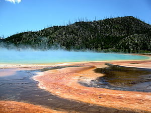
地球の地熱の特徴の半分を備えたイエローストーンは、間欠泉、温泉、泥泉、噴気孔の地球上で最も多様で無傷のコレクションを保持しています。 300を超える間欠泉は、地球上で見られる間欠泉の3分の2を占めています。鮮やかな色の温泉、泡立つ泥泉、噴気孔など、10,000以上の温泉と組み合わせれば、他にはない場所になります。
イエローストーンの熱水機能は、途方もない熱を放出する基礎となるマグマ体なしには存在しませんでした。また、イエローストーン高原を取り巻く山々などの水源にも依存しています。そこでは、雪と雨が、亀裂でいっぱいの浸透性の岩の層をゆっくりと浸透します。この冷たい水の一部は、浅いマグマ体によって直接加熱された熱い塩水と出会う。水の温度は沸点をはるかに超えて上昇しますが、上にある水の圧力と重量が大きいため、水は液体状態のままです。その結果、温度が400°F(200°C)を超える過熱水が発生します。
過熱水は、その周りに沈む冷たくて重い水よりも密度が低くなります。これにより対流が発生し、より軽く、より浮力のある過熱水が、流紋岩質溶岩流を介して亀裂や弱い領域に続いて地表に戻る旅を開始できるようになります。この上向きの道は、公園の熱水機能の自然な「配管」システムです。それが表面に達すると、プールのさまざまな色は、さまざまな温度で成長するさまざまな種類のバクテリアによるものです。
植物と動物

この公園は、地球上に残っている最大の無傷の温帯生態系の1つである大イエローストーン生態系の中核であり、その結果、野生生物を観察するための特別なエリアです。
イエローストーンは、米国本土48州で哺乳類が最も集中している場所です。ここには、ハイイログマやツキノワグマなど、67種類の哺乳類が生息しています。灰色のオオカミは1926年までに絶滅の危機に瀕していましたが、1995年にカナダから再導入され、現在100頭以上が公園に生息しており、野生で見るのに最適な場所の1つとなっています。さらに、公園にはコヨーテやアカギツネの繁殖地もあります。邪魔されない生息地の広い広がりを必要とするウルヴァリンとオオヤマネコは、イエローストーン生態系にも見られます。ワピチ、ミュールジカ、バイソン、ムース、オオツノヒツジ、プロングホーン、オジロジカの7つの有蹄動物がここに生息しています。公園の北部には外来種のシロイワヤギが植民地化しており、公園全体にビーバーを含む多数の小型哺乳類が見られます。
イエローストーンは1872年の設立以来、鳥の目撃記録が保管されています。これらの記録には、これまでに330種の鳥が記録されており、そのうち約148種が公園に営巣していることが知られています。公園内で見られる標高の変化と生息地の種類の幅広い配列は、この地域の比較的高い多様性に貢献しています。
氷河活動と現在の涼しく乾燥した状態が、公園で見つかった爬虫類と両生類の数が比較的少ない原因である可能性があります。
イエローストーンには1,350種以上の維管束植物が生息しており、そのうち218種は外来種です。
気候
| イエローストーン国立公園 | ||||||||||||||||||||||||||||||||||||||||||||||||||||||||||||
|---|---|---|---|---|---|---|---|---|---|---|---|---|---|---|---|---|---|---|---|---|---|---|---|---|---|---|---|---|---|---|---|---|---|---|---|---|---|---|---|---|---|---|---|---|---|---|---|---|---|---|---|---|---|---|---|---|---|---|---|---|
| 気候チャート(説明) | ||||||||||||||||||||||||||||||||||||||||||||||||||||||||||||
| ||||||||||||||||||||||||||||||||||||||||||||||||||||||||||||
| ||||||||||||||||||||||||||||||||||||||||||||||||||||||||||||
イエローストーン国立公園の天気は、晴れて暖かいものから寒くて雨が降るまで非常に急速に変化する可能性があるため、必要に応じて使用できる衣類の追加の層を持参することが重要です。イエローストーンでは一年中いつでも雪が降る可能性があります。
- 夏:日中の気温は、標高が低い場合は70年代(25°C)であることが多く、80年代(30°C)である場合もあります。夜は通常涼しく、標高が高くなると気温が氷点下に下がる場合があります。午後には雷雨がよく発生します。
- 冬:気温は、多くの場合、1日を通して0から20°F(-20から-5°C)の範囲です。一晩の氷点下の気温が一般的です。記録的な低温は-66°F(-54°C)です。降雪量は大きく変動します。平均は年間150インチ(3,800 mm)ですが、標高が高くなるとその2倍になることも珍しくありません。
- 春秋:日中の気温は30〜60度(0〜20°C)で、10代の夜間の最低気温は1桁(-5〜-20°C)です。春と秋には雪がよく降り、24時間で定期的に12インチの積雪があります。一年中いつでも、突然の変化に備えてください。何よりも予測不可能なことが、イエローストーンの天気の特徴です。常に広い装備を備えています。さまざまな衣類のオプション。夏でも暖かいジャケットと雨具を必ず持参してください。
入れ

飛行機で
イエローストーンにサービスを提供する主要空港は ジャクソンホール空港 (JAC IATA)、で グランドティトン国立公園、近く ジャクソン、およびで最大の空港 ワイオミング。ユナイテッドとデルタは、ジャクソンホールに一年中サービスを提供しています。 デンバー そして ソルトレイクシティ それぞれ。これらの航空会社に加えて、アメリカン航空とフロンティア航空は、これらの都市と米国中の他の8つの都市からの季節便を提供しています。
商業サービスを提供する他の空港は次のとおりです。
- ビリング (モンタナ)(BIL IATA)。多くの都市から。
- ボーズマン (モンタナ)(BZN IATA)。年間を通じて8つの都市から、さらに季節ごとに。
- コーディ (ワイオミング)(代金引換 IATA)、イエローストーン地域空港。ソルトレイクシティとデンバーから。
- アイダホフォールズ (アイダホ)(IDA IATA)。 6つの都市から。
- ソルトレイクシティ (ユタ)(SLC IATA)。少し長いドライブ(約6時間)ですが、それでも公園に最も近い主要空港であり、全国の主要都市からのフライトと限られた国際線があります。
- ウエストイエローストーン (モンタナ)(WYS IATA)。ソルトレイクシティから、6月から9月のみ。
車で
公園には5つの入り口があります。各入り口に最も近い都市が示されています。
- 1 北 -からアクセス ガーディナー(モンタナ) 米国ルート89経由、から56マイル(90 km) リヴィングストン。この入り口は一年中開いており、公園の本部に通じています。 マンモス温泉、公園の境界内5マイル(8.0 km)。象徴的な ルーズベルトアーチ この入り口にあります。
- 2 北東 -からアクセス シルバーゲート そして クックシティ USルート212(ベアトゥースハイウェイ)経由。クックシティへの入り口と道路は一年中開いていますが、クックシティを通過する国道212号線は冬(10月中旬から5月下旬)に閉鎖されます。
- 3 東 -からアクセス コーディ、53マイル(85 km)、米国ルート14/16/20経由。この入り口は冬(11月上旬から5月上旬)は閉鎖されます。
- 4 南 -からアクセス グランドティトン国立公園 米国ルート89/191/287経由。この入り口は冬(11月上旬から5月中旬)は閉鎖されます。
- 5 西 -からアクセス ウエストイエローストーン 米国ルート20/191/287経由、から60マイル(97 km) アイダホ州アシュトン。この入り口は冬(11月上旬から4月下旬)は閉鎖されます。
徒歩で
長さ3100マイル(5000 km)を含む、公園に入る多数のトレイルが四方にあります。 コンチネンタルディバイドトレイル.
料金と許可
公園に入るすべての車両と個人は、7日間有効な入場料を支払う必要があります。 2020年現在の料金は次のとおりです。
- 20ドル-徒歩、自転車などで個人
- 30ドル-オートバイまたはスノーモービル。
- 35ドル-非商用車。
- 70ドル-イエローストーン国立公園の年間パス。自家用車で1年間公園にアクセスできます。
過去にはイエローストーンへの入場料には入場料も含まれていました グランドティトン国立公園、両方の公園を訪れる予定の訪問者は、それぞれに別々の入場料を支払う必要があります。
いくつかあります パス イエローストーン国立公園とすべての国立公園、およびいくつかの国定公園、国有野生生物保護区、国有林への無料入場を提供する自家用車または徒歩/自転車で一緒に旅行するグループの場合:
- 80ドル 年間パス (発行日から12ヶ月間有効)はどなたでもご購入いただけます。軍人は、Common Access Card(CAC)またはMilitaryIDを提示することでフリーパスを取得できます。
- 80ドル シニアパス (所有者の存続期間中有効)は、米国市民または62歳以上の永住者が利用できます。申請者は、市民権と年齢の文書を提出する必要があります。このパスでは、一部の公園のアメニティが50%割引になります。高齢者は、年間20ドルのパスを取得することもできます。
- 無料 アクセスパス (所有者の存続期間中有効)は、米国市民または永住者が利用できます。申請者は、市民権と永続的な障害の文書を提供する必要があります。このパスでは、一部の公園のアメニティが50%割引になります。
- 無料 ボランティアパス 省庁間パスプログラムに参加している連邦政府機関で250時間以上ボランティアをしている個人が利用できます。
- 無料 年間4年生パス (4年生の9月から8月に有効)は、自家用車で持ち主と同行する乗客の入場を許可します。での登録 アウトドアのすべての子供 ウェブサイトが必要です。
国立公園局は、毎年5日間、すべての国立公園への無料入場を提供しています。
- マーティンルーサーキングジュニアデー(1月の第3月曜日);次の遵守は2021年1月18日です
- 国立公園ウィークの初日(4月の第3土曜日)。次の遵守は2021年4月17日です
- 国立公園局の誕生日(8月25日)
- 全国公有地の日(9月の第4土曜日);次の遵守は2021年9月25日です
- 復員軍人の日(11月11日)
移動する

自分の向きを決めるのに便利な方法は、イエローストーン内の道路を「8の字」の形に視覚化することです。下のループ、ウェストサム-オールドフェイスフル-マディソン-ノリス-キャニオン-レイクビレッジ-ウェストサムは、約90マイル(140キロメートル)です。上部のループ、ノリス-マンモス-タワー-ルーズベルト-キャニオン-ノリスは、約70マイル(110キロメートル)の周りにあります。公園は 大.
車で
ほとんどの訪問者は、イエローストーン国立公園内を移動するために自家用車を使用しています。人々が野生生物を見るために立ち止まると、道路は非常に混雑する可能性があります。プルアウトを使用し、他のドライバーを尊重して回避する クマジャム。雪が降ると道路が閉鎖されることがあり、冬の間は多くの公園の道路が完全に閉鎖されます。
バスで
公園内には公共交通機関はありません。 Xanterra Resorts 夏季には公園内のバスツアーを提供しています。ローワーループツアーは、公園の南部のみの場所から出発します。アッパーループツアーは、レイクホテル、フィッシングブリッジRVパーク、キャニオンロッジから出発し、公園の北部のみをツアーします。グランドループツアーは、ガーディナーとマンモスホットスプリングスホテルから出発し、1日で公園全体をツアーします。冬季には、さまざまな場所からスノーコーチツアーが提供されます。情報や予約については、1 307344-7311までお電話ください。
さらに、夏のシーズン中、商業企業は多くの地域の町や都市から出発するツアーを提供します。冬の間、一部の企業は、マンモス温泉からクックシティ道路までのほとんどの公園道路またはバス輸送にスノーコーチツアーを提供しています。
自転車で
サイクリング 公園での滞在は非常にやりがいのある経験になる可能性がありますが、公園内の距離が遠いため、毎晩宿泊施設を利用できるようにするために追加の計画が必要です。公園はサイクリストのために多くのキャンプ場を予約していますが、忙しい夏のシーズン中は、可能な限り事前にサイトを予約するのがおそらく最善です。
スノーモービルまたはスノーコーチ
訪問者が最も少ない冬は、おそらく公園を訪れるのに最も静かな時期です。スノーモービルとスノーコーチの旅行の冬の使用シーズンは12月中旬に始まり、3月中旬に終わります。雪上旅行の実際の開始日または終了日は、入り口によって異なり、適切な積雪と耕起のスケジュールによって決定されます。スノーモービルまたはスノーコーチで公園を訪問したい訪問者は、商用スノーモービルで旅行するか、ほとんどの入り口にあるスノーモービル(プライベート、ガイドなしのスノーモービル、スノーコーチは許可されていません)の商用ガイドに同行する必要があります。利用可能な最高のテクノロジースノーモービルが必要であり、スノーモービルとスノーコーチのエントリーには1日あたりの制限があります。スノーモービルやスノーコーチのオフロードでの使用は禁止されています。
見る

イエローストーンは、その自然遺産と美しさで世界的に有名です。また、10,000を超える例があり、世界の地熱の特徴の半分を保持しているという事実でも有名です。イエローストーンへの旅行者は、地球の表面に立っている間、300を超える間欠泉(「オールドフェイスフル」など)、沸騰した泥のプール、ハイイログマ、オオカミ、バイソン、エルクなどの野生生物の驚くべき集合体を見ることができます。最大の知られている「超火山」。
公園は約8つの主要なエリアに細分できます。これらのエリアは、東から時計回りに公園を移動する人が遭遇するため、以下に編成されています。
ブリッジベイ、フィッシングブリッジ、レイク
これらの3つの地域は、イエローストーン湖の北側にあります。レクリエーションのオプションには、ボート、釣り、およびいくつかの熱機能が含まれます。
この地域の熱的特徴と自然の魅力は次のとおりです。
- 1 イエローストーン湖. 表面積が132平方マイル(340平方キロメートル)のイエローストーン湖は、北アメリカで最大の標高(7,000フィート以上)の湖です。それは海抜7,733フィート(2,357 m)に位置する自然の湖です。長さは約20マイル(32 km)、幅は15マイル(24 km)で、海岸線は141マイル(227 km)です。半年近く凍っています。 12月下旬または1月上旬に凍結し、5月下旬または6月上旬に解凍します。


- ヘイデンバレーとペリカンバレー. ヘイデンバレーはフィッシングブリッジジャンクションの北6マイル(9.7 km)にあります。ペリカンバレーはフィッシングブリッジの東3マイル(4.8 km)にあります。これらの2つの広大な谷は、ハイイログマ、バイソン、ワピチ、およびその他の野生生物種にとって、米国本土48州で最高の生息地のいくつかを構成しています。
- 2 ナチュラルブリッジ (ブリッジベイキャンプ場のすぐ南). この岩層には、1.6 km(1マイル)の徒歩で簡単にアクセスできます。また、橋につながる自転車用トレイルもあります。ナチュラルブリッジは、ブリッジクリークによる流紋岩露頭の侵食によって形成されました。橋の頂上は小川から約51フィート(16 m)上にあります。短いスイッチバックトレイルが頂上に通じていますが、この機能を保護するために橋を渡る移動は現在禁止されています。
- 3 ルハーディラピッズ (フィッシングブリッジの北3マイル(4.8 km)). ルハーディラピッズはイエローストーン川の滝です。地質学的には、これが湖が終わり、川が北向きに流れ続ける実際の場所であると考えられています。春には、ここで多くのノドキリマスが見られ、浅いプールで休んでから、フィッシングブリッジの下で産卵する途中で急流を跳ね上げるためにエネルギーのバーストを消費します。 1984年に建てられた遊歩道は、この敏感な鳥の生息地を保護するために春の営巣シーズン中は閉鎖されていますが、この地域へのアクセスを提供します。
- 4 泥火山. これはかつて、噴火の際に近くの木に泥を投げ込む丘の上の熱的特徴でしたが、特に大規模な噴火が泥火山を吹き飛ばし、丘のふもとに熱い泡立つ泥のプールを残しました。この地域へのアクセスは、駐車場から障害者が利用できるマッドボルケーノを過ぎた短いループと、サワーレイクと比較的急なブラックドラゴンの大釜を経由する800 m(0.5マイル)の上部ループトレイルを経由します。 。蒸気のリズミカルなげっぷと水の舌の点滅は、ドラゴンの口の春にその名前を付けていますが、その活動は1994年12月以降著しく減少しています。ブラックドラゴンの大釜は、1948年に風景に爆発し、根で木を吹き飛ばし、周囲を覆いました。泥の森。 1995年1月、マッドガイザーの南岸にある新機能が非常に活発になり、20 x 8フィート(6.1m×2.4m)の領域をカバーし、噴気孔、小さなプール、フライパンタイプの機能で構成されました。 「ガンパー」として知られる巨大な泥泉を含む泥火山地域の最も劇的な特徴は、遊歩道外のレンジャーガイド付きの散歩を通じてのみ一般に公開されています。
- 5 サルファーカルドロン. サルファーカルドロンエリアは、泥火山のすぐ北にあるステージングエリアから見ることができます。サルファーカルドロンの黄色い乱流の水しぶきは、pH1.3の公園で最も酸性の水です。この見落としから見ることができる他の特徴は、乱流プール(もはや「乱流」ではない)と大きくて活発な泥の壺の火口です。
この地域の歴史的および教育的アトラクションは次のとおりです。
- 6 フィッシングブリッジ. 元の橋は、現在の橋とはわずかに異なる配置の荒削りのコーデュロイ丸太橋として1902年に建設されました。既存の橋は1937年に建設されました。フィッシングブリッジは歴史的に非常に人気のある釣り場でした。橋からの釣りは、ノドキリマスの主要な産卵場所であったため、非常に良かった。しかし、この慣行の結果、カットスロートの個体数が減少したため、1973年に橋は漁業を停止しました。それ以来、橋は魚を観察する人気の場所になりました。
- 7 フィッシングブリッジミュージアムアンドビジターセンター. フィッシングブリッジ博物館は1931年に完成し、最終的には全国の公園の素朴な建築のプロトタイプになりました。 1987年に国定歴史建造物に指定されました。公園内の主要な交通手段として自動車が駅馬車に取って代わったとき、人々はガイドを伴わなくなったため、博物館は訪問者が情報を入手できる「トレイルサイド博物館」として建設されました。イエローストーンについて。
- 8 レイクイエローストーンホテル. レイクイエローストーンホテルは、インド人、わな猟師、マウンテンマンの待ち合わせ場所として長い間知られている場所に1891年にオープンしました。当時、それは特に特徴的ではなく、ノーザンパシフィック鉄道によって資金提供された他の鉄道ホテルに似ていました。 1903年に改装され、1929年に追加の変更が加えられました。1970年代までに、ホテルは深刻な荒廃に陥っていました。 1981年、国立公園局と公園コンセッショネアであるTW Recreational Servicesは、1920年代の栄光の時代に外観を復元するための10年間のプロジェクトに着手しました。作業は1991年にホテルの100周年を祝うために終了しました。ホテルはその年に国家歴史登録財に登録されました。
- 9 レイクレンジャーステーション. イエローストーンでの10年間の軍事政権の後、議会は1916年に国立公園局を創設しました。レンジャーステーションが公園全体の兵士ステーションに取って代わり始めました。レイクレンジャーステーションは1923年に完成しました。国立公園局の最初のディレクターであるスティーブンマザーは、ステーションがその自然と文化的環境に溶け込むべきであると提案しました。地元の森の人が先駆的な建築技術を使用して、駅に「トラッパーキャビン」スタイルを与えました。公園の建築家とともに、ホレスオルブライト監督は、中央に石造りの暖炉がある大きな八角形の「コミュニティルーム」を設計しました。この素朴なホールは、昼間は情報提供を行い、夕方には暖炉の周りに民俗が集まるシーンになりました。
- 10 レイクロッジ. 1915年に公園で自動車が登場したことで、多くの訪問者が訪れました。レイクホテルの豪華さとテントキャンプの素朴な宿泊施設の間の中間的なスタイルの宿泊施設の必要性が生じました。 1926年、公園内にある4つのロッジの1つであるレイクロッジ(ロバートリーマーのデザイン)が完成しました。公園はもはや、裕福な「男」や心のこもった「賢者」だけが主にアクセスすることはできませんでした。
ウェストサム&グラントビレッジ

これらの2つの村はイエローストーン湖の西側にあり、ボート、釣り、そして湖に直接泡立つ温泉「フィッシングコーン」などのいくつかの興味深い温泉機能を提供しています。この地域の名前は、少し想像力を働かせれば、イエローストーン湖が左手が南に向かっているように見え、この地域がその手の「親指」になるという事実に由来しています。
この地域の熱的特徴と自然の魅力は次のとおりです。
- 11 イエローストーン湖. レイクビレッジやフィッシングビレッジと同様に、このエリアからは北米最大の標高の高い湖にアクセスできます。湖の最上層が19°C(66°F)を超えることはめったになく、下層ははるかに低温です。水が非常に冷たいため、水泳はお勧めしません。
- 12 ウェストサムガイザーベイスン. この間欠泉盆地は、海岸に沿って2マイル(3.2 km)の距離にあり、そこから約500ヤード(460 m)戻って、おそらく何フィートも湖に伸びています。ここには数百の泉があり、ミニチュアの噴水から直径75フィート(23 m)の深さのあるプールや井戸まで、さまざまなサイズがあります。さらに、泥の湧き水の小さなクラスター。特に注目すべきは、アビースプールは目の錯覚で底なしに見えることです。フィッシングコーンは、この部分的に水没した温泉に魚を浸して調理するスポットとしてかつて人気があったオフショアプールです。 (このスタントは許可されなくなりました。)
- 13 ハートレイク. ルイス湖の西とイエローストーン湖の南にあるスネーク川流域にあるハート湖は、1871年以前に初期のハンターであるハートハニーにちなんで名付けられました。
- 14 イサ湖. この湖は1891年にクレイグパスの大陸分水嶺にあります。イサ湖はおそらく地球上で唯一、東側が太平洋に、西側が大西洋に向かって2つの海に自然に流れ込む湖として注目に値します。
- 15 レッドマウンテン. ハートレイクのすぐ西にあるこの小さな山脈は、イエローストーン国立公園の境界内に完全に含まれています。範囲の名前は、それらを構成する火山岩の色に由来します。範囲内には12のピークがあり、高さ10,308フィート(3,142 m)のマウントシェリダンが最も高くなっています。
- 16 ショーション湖. この湖は公園で2番目に大きい湖であり、ウェストサムの南西にあるルイス川の上流にあります。ショーション湖の最大水深は205フィート(62 m)で、面積は8,050エーカー(32.6平方キロメートル)です。ショーション湖は、ルイス川の滝のために魚の不毛でしたが、現在、湖にはレイクトラウト、ブラウントラウト、ユタチャブが導入されています。合衆国魚類野生生物局は、ショーション湖が米国本土48州で最大の湖であり、道路で行くことができないと考えています。湖へのモーターボートの乗り入れは禁止されています。
この地域の歴史的および教育的アトラクションは次のとおりです。
- 17 ウェストサムレンジャーステーション. 1925年に建てられ、1966年に開いたそよ風が囲まれたウェストサムレンジャーステーションは、イエローストーンのレンジャーステーションに関連する歴史的建造物の優れた例です。
オールドフェイスフル

オールドフェイスフルは、イエローストーンについて人々が考えるイメージであり、間欠泉は定期的に噴火します(推定噴火時間についてはビジターセンターを確認してください)。このエリアには、象徴的で歴史的なオールドフェイスフルインのほか、遊歩道から簡単にアクセスできる間欠泉や温泉が数多くあります。
この地域の熱的特徴と自然の魅力は次のとおりです。
- 18 アッパーガイザーベイスン. イエローストーンは全体として、世界の間欠泉の60%近くを所有しており、アッパーガイザーベイスンには、象徴的な「オールドフェイスフル」間欠泉を含む、公園で見つかったこの壊れやすい特徴の最大数があります。世界で最も有名な間欠泉であるオールドフェイスフルでは、大規模な噴火が平均して80分に1回発生しますが、各噴火のタイミングは1時間も異なり、年々増加しています。レンジャーは、前の噴火の期間がわかっていれば、間欠泉の噴火を約10分以内に予測することができます。オールドフェイスフルに加えて、この盆地には1平方マイル(0.65 km)以内に150の間欠泉が追加されています。2) 範囲;この驚くべき数のうち、キャッスル、グランド、デイジー、リバーサイド、オールドフェイスフルの噴火は博物学者のスタッフによって定期的に予測されています。間欠泉に加えて、この地域には数多くの温泉があります。遊歩道は、最も興味深いエリアへのアクセスを可能にします。 トレイルを離れないでください;ここの表面は薄くて不安定で、あなたが想定外の場所を歩くと、沸騰したお湯のプールにあなたを沈める可能性があります。
- 19 ローワーガイザーベイスン. 熱水活動のこの広いエリアは、ファウンテンペイントポットの遊歩道に沿って徒歩で、3マイル(4.8 km)のファイアーホールレイクドライブに沿って車で見ることができます。後者は片道のドライブで、オールドフェイスフルのスタッフが予測した6番目の間欠泉であるグレートファウンテンがあります。その派手な噴火は、100〜200フィート(30〜60メートル)のダイヤモンド液滴の噴流を空中に送り、水の波が隆起したテラスを流れ落ちます。予測では2時間(プラスまたはマイナス)の機会が与えられるため、この1日2回の間欠泉には忍耐力があります。ファウンテンフラットドライブは、ネズパースのピクニックエリアのすぐ南にあるグランドループロードを出発し、ファイアーホール川に沿って1.5マイル(2.4 km)離れたトレイルヘッドまで続きます。そこから、ファウンテンフレイトロードのハイキング/サイクリングトレイルが古い路盤に沿って続き、ハイカーはセンティネルメドウズトレイルとフェアリーフォールズトレイルにアクセスできます。また、この道に沿って、グース湖のオールドフェイスフル地区で唯一の障害者が利用できるバックカントリーサイトがあります。
- 20 ミッドウェイガイザーベイスン. この間欠泉盆地は、ファイアーホール川を見下ろす丘の上にあります。この地域の他の間欠泉盆地よりもサイズが小さく、その熱的特徴からの流出が川に流れ込み、その跡に蒸し暑いカラフルな小道が残ります。特に、Excelsior Geyserは、毎分4,000米ガロン(15,000リットル)以上の水をファイアーホール川に絶えず放出している、200フィート×300フィート(60m×90m)の隙間のある火口を明らかにしています。この間欠泉はかつて非常に激しく噴火したため、実際には爆発した可能性があり、その後は噴火は発生していません。また、この驚くべき盆地には、イエローストーン最大の温泉、美しい色のグランドプリズマティックスプリングがあります。この機能は、直径370フィート(110 m)、深さ160フィート(50 m)です。フェアリーフォールズトレイルヘッドは、春の後ろの丘にある展望台へのアクセスを提供し、盆地全体の高架ビューを取得できます。
- 21 ローンスターガイザーベイスン. このバックカントリーの間欠泉盆地には、オールドフェイスフルの南にあるトレイルヘッドから現在閉鎖されている古い道路をたどる5マイル(8.0 km)の往復ハイキングで簡単に行くことができます。ローンスターガイザーは約3時間ごとに噴火します。間欠泉の時間と噴火の種類を観察するために、間欠泉の近くのキャッシュにログブックがあります。自転車はローンスターへの道のほとんどを作ることができます。
- 22 ショーションガイザーベイスン. ショーションガイザーベイスンには、グランツパスで大陸分水嶺を横断する17マイル(27 km)の往復ハイキングがあります。この盆地には遊歩道がないため、この盆地を移動するときは細心の注意を払う必要があります。流域のトレイルを使用する必要があります。このような遠隔地の熱地域には、敬意、知識、および注意を払ってアプローチする必要があります。バックカントリー盆地に入るときは、必ず個人の安全と資源保護を強調してください。
- 23 ファイアーホール川. 川の名前は、この地域への初期の捕獲者が目撃した蒸気(彼らは火からの煙だと彼らが考えていた)に由来しています。彼らの山の谷の用語は「穴」であり、その呼称が生まれました。ファイアーホール川は、フライフィッシングに挑戦することで世界的に有名な評判を誇っています。ブラウン、レインボー、カワマスは、このストリームで釣り人に用心深いターゲットを与えます。
- 24 ケプラーカスケード. これは、地区で最も簡単に到達できる滝です。オールドフェイスフルのすぐ南にあるマーク付きの引き出しと車から歩いてすぐの場所にあるため、訪問者はこの125フィート(38 m)のカスケードを簡単に見ることができます。
- 25 モーニンググローリープール. 花にちなんで名付けられた「朝顔」(渦巻き)、プールが似ています。プールの色は、水に生息するバクテリアによるものです。プールはめったに噴火しません。最近、観光客がピットに物を投げ込んだことによる目詰まりで色が変わった。
この地域の歴史的および教育的アトラクションは次のとおりです。
- 26 オールドフェイスフルイン. 1903-04年の冬に建てられたオールドフェイスフルインは、米国に残っている数少ないログホテルの1つです。それは、その様式化されたデザインと優れた職人技の素朴な建築の傑作です。アメリカの建築、特に公園の建築への影響は計り知れませんでした。建物は素朴な丸太と木造の構造で、長さ約700フィート(210 m)、高さ7階建ての巨大なプロポーションを備えています。ホテルのロビーには、65フィート(20 m)の天井、巨大な流紋岩の暖炉、ゆがんだロッジポールパインで作られた手すりがあります。訪問者はロビーの真ん中に立ってむき出しの構造を見上げるか、節くれだった丸太の階段を上ってバルコニーの1つに行き、上、下、または向こう側を見上げることができます。 1915年と1927年にホテルに翼が追加され、現在、この国定歴史建造物には327室の客室があります。
- 27 ローワーハミルトンストア. 1897年に建てられたこの建造物は、現在も使用されているオールドフェイスフル地域で最も古い建造物です。 「節のある松」のポーチは、訪問者に人気の休憩場所であり、間欠泉の丘の素晴らしい景色を眺めることができます。 (オールドフェイスフルで最も古い建物は、1897年にF.ジェイヘインズのために写真スタジオとして建てられました。以前はビーハイブガイザーの南西700フィート(210 m)、オールドフェイスの正面の北西約350フィート(110 m)にありました。フェイスフルインですが、現在はグランドループロードとファイヤーレーンの交差点の近く、交差点の近くにあります。)
マディソン
マディソンはオールドフェイスフルとノリス間欠泉盆地の中間にあり、さまざまな熱機能を提供しています。
- 28 アーティストペイントポット. Artists Paintpotsは、ノリスジャンクションのすぐ南にある小さいながらも素敵な温泉エリアです。 1マイル(1.6 km)の往復トレイルでは、訪問者は色とりどりの温泉、2つの大きな泥の壺、1988年に焼失した森林の一部を通ります。このエリアに隣接するのは、他の3つのオフトレイルのバックカントリーサーマルエリアです。シルバンスプリングス、ギボンヒルガイザーベイスン、ガイザークリークサーマルエリア。これらの領域は壊れやすく、危険であり、到達するのが困難です。知識のある人がいない旅行はお勧めしません。
- 29 ギボン滝. この84フィート(26 m)の滝は、イエローストーンカルデラの縁の残骸の上を転がり、公園の道路のプルオーバーから簡単にアクセスできます。滝から道路の反対側にある岩壁は、カルデラの内側の縁です。
- 30 モニュメントガイザーベイスン. この小さな、ほぼ休眠中の盆地は、非常に急な1マイル(1.6 km)のトレイルの頂上にあります。この地域のハイライトには、はるかに活発な時代の名残である魔法瓶型の間欠泉の円錐形、いくつかの興味深いトラバーチン構造、およびいくつかの素晴らしい景色が含まれます。
- 31 マディソン川. マディソン川は、ギボン川とファイアーホール川の合流点、つまりマディソン合流点で形成されます。マディソンはモンタナ州スリーフォークスでジェファーソン川とガラティン川に合流し、ミズーリ川を形成します。マディソンは、ブラウンとニジマス、そしてマウンテンホワイトフィッシュの健康的な資源を備えたブルーリボンフライフィッシングストリームです。川によって作られた峡谷は、両側にある急な木で覆われた岩壁で構成されています。
- 32 テラススプリング. マディソンジャンクションのすぐ北にある小さなサーマルエリア。このエリアでは、訪問者に温泉の短い遊歩道ツアーを提供しています。
- 33 ファイアーホールキャニオンドライブとファイアーホール滝. 脇道であるファイアーホールキャニオンドライブは、マディソンジャンクションの上流のファイアーホール川に沿ってファイアーホール滝の真上まで続きます。ドライブは、800フィート(240 m)の厚い溶岩流を通り過ぎて観光客を連れて行きます。ファイアーホール滝は40フィート(12 m)の滝です。ここの無人のスイミングエリアは、夏の最も暖かい季節に非常に人気があります。クリフダイビングは違法です。
- 34 国立公園山. 山はマディソンジャンクションエリアを取り囲む溶岩流の一部です。この場所の近くで、1870年に、ウォッシュバーン-ラングフォード-ドアン遠征隊がキャンプし、彼らが探検していた地域の将来について話し合ったと言われています。伝説によると、ここで国立公園のアイデアが議論されましたが、キャンプファイヤーの会話が行われたという証拠はなく、国立公園のアイデアが議論されたことを示す証拠は確かにありません。
ノリス

South of Mammoth, the Norris area is a home to a vast array of thermal features, including Steamboat Geyser, the world's largest. The area was named after Philetus W. Norris, the second superintendent of Yellowstone, who provided the first detailed information about the thermal features.
Thermal features and natural attractions in this area include:
- 35 Norris Geyser Basin. Norris Geyser Basin is the hottest, oldest, and most dynamic of Yellowstone's thermal areas. The highest temperature yet recorded in any geothermal area in Yellowstone was measured in a scientific drill hole at Norris: 459 °F (237 °C) just 1,087 ft (331 m) below the surface, and there are very few thermal features at Norris under the boiling point (199 °F or 93 °C at this elevation). Norris shows evidence of having had thermal features for at least 115,000 years. The features in the basin change daily, with frequent disturbances from seismic activity and water fluctuations. Steamboat Geyser, the tallest geyser in the world (300 to 400 feet or 90 to 120 metres) and Echinus Geyser (pH 3.5 or so) are the most popular features. The basin consists of three areas: Porcelain Basin, Back Basin, and One Hundred Springs Plain. Porcelain Basin is barren of trees and provides a sensory experience in sound, color, and smell; a 3/4-mile (1.2 km) dirt and boardwalk trail accesses this area. Back Basin is more heavily wooded with features scattered throughout the area; a 1.5-mile (2.4 km) trail of boardwalk and dirt encircles this part of the basin. One Hundred Springs Plain is an off-trail section of the Norris Geyser Basin that is very acidic, hollow, and dangerous. Travel is discouraged without the guidance of knowledgeable staff members.
- 36 とどろく山. Next to the park road just north of Norris on the Norris-Mammoth section of the Grand Loop Road, Roaring Mountain is a large, acidic thermal area (solfatara) that contains many steam vents (fumaroles) which make noises ranging from a nearly inaudible whisper to a roar that can be heard miles away. In the late 1800s and early 1900s, the number, size, and power of the fumaroles was much greater than today.
- 37 Gibbon River. The Gibbon River flows from Wolf Lake through the Norris area and meets the Firehole River at Madison Junction to form the Madison River. Both cold and hot springs are responsible for the majority of the Gibbon's flow. Brook trout, brown trout, grayling, and rainbow trout find the Gibbon to their liking. The Gibbon River is fly-fishing only below Gibbon Falls.
- 38 Virginia Cascades. A three-mile (4.8 km) section of the old road takes visitors past 60-foot (18 m) high Virginia Cascades. This cascading waterfall is formed by the very small (at that point) Gibbon River.
- Norris-Canyon Blowdown. This is a 22-mile (35 km) swath of lodgepole pine blown down by wind-shear action in 1984. It was then burned during the North Fork fire in 1988. This is the site where a famous news anchor said, "Tonight, this is all that's left of Yellowstone." A wayside exhibit there tells the story.
Historical and educational attractions in this area include:
- 39 The Norris Soldier Station. The Norris Soldier Station (Museum of the National Park Ranger) was an outlying station for soldiers to patrol and watch over Norris Geyser Basin. It was among the longest occupied stations in the park. A prior structure was built in 1886, replaced after fire in 1897, and modified in 1908. After the Army years, the building was used as a Ranger Station and residence until the 1959 earthquake caused structural damage. The building was restored in 1991.
- 40 The Norris Geyser Basin Museum. The Norris Geyser Basin Museum is one of the park's original trailside museums built in 1929-30. It has always been a museum. It is an outstanding example of a stone-and-log architecture.
マンモス

Mammoth is home to the park headquarters and the impressive calcite terraces of Mammoth Hot Springs. This area has numerous services and is a surprisingly good place to see elk grazing on the manicured lawns surrounding the park administrative buildings.
Thermal features and natural attractions in this area include:
- 41 Mammoth Hot Springs. These mammoth rock formations are the main attraction of the Mammoth District and are accessible via boardwalk. These features are quite different from thermal areas elsewhere in the park as travertine formations grow much more rapidly than sinter formations due to the softer nature of limestone. As hot water rises through limestone, large quantities of rock are dissolved by the hot water, and a white chalky mineral is deposited on the surface. Formations here change rapidly, and while a favorite spring may appear to have "died," it is important to realize that the location of springs and the rate of flow changes daily, that "on-again-off-again" is the rule, and that the overall volume of water discharged by all of the springs fluctuates little.
- 42 The Gardner River and Gardner River Canyon. The North Entrance Road from Gardiner, Montana, to Mammoth Hot Springs, Wyoming, runs along the Gardner River. The road winds into the park, up the canyon, past crumbling walls of sandstone and ancient mudflows. The vegetation is much thicker in the canyon than on the open prairie down below, the common trees being Rocky Mountain juniper, cottonwood, and Douglas-fir. Low-growing willows also crowd the river's edge in the flatter, flood-prone sections of the canyon. Watch for wildlife in season: eagles, osprey, dippers, and kingfishers along the river and bighorn sheep in the steeper parts of the canyon.
- 43 45th Parallel Bridge and Boiling River. A sign north of where the road crosses the Gardner River marks the 45th parallel of latitude.標識の少し南にある道路東側の駐車場は、公園内で数少ない自然の湯に浸かることができる「沸騰する川」の入浴者が利用しています。 Bathers must walk upstream about a half mile (800 m) from the parking area to the place where the footpath reaches the river.この場所はまた、特に寒い時期には、大きな蒸気の雲が特徴です。ここでは、マンモステラスからの温水流出がガードナー川に入ります。川の端に沿ったプールで温水と冷水が混ざり合っています。入浴者は日中のみ川に入ることができます。水着が必要で、アルコール飲料は禁止されています。沸騰する川は危険な高水のために春に閉鎖され、真夏まで再開しないことがよくあります。混雑する傾向がありますので、繁忙期の早朝に訪れてみてください。
- 44 山Everts. 山Everts was named for explorer Truman Everts of the 1870 Washburn Expedition who became separated from his camping buddies, lost his glasses, lost his horse, and spent the next 37 days starving and freezing and hallucinating as he made his way through the un-tracked and inhospitable wilderness. Upon rescue, he was, according to his rescuers, within but a few hours of death. Everts never made it quite as far as Mt. Everts. He was found near the "Cut" on the Blacktail Plateau Drive and was mistaken for a black bear and nearly shot. His story, which he later published in スクリブナーズマンスリーマガジン, remains one of Yellowstone's best known, lost-in-the-wilderness stories. It has also been published in book form, edited by Yellowstone's archivist Lee Whittlesey under the name Lost in the Yellowstone.山Everts is made up of distinctly layered sandstones and shales--sedimentary rocks deposited when this area was covered by a shallow inland sea, 70 to 140 million years ago.
- 45 ブンセンピーク. Bunsen Peak and the "Bunsen burner" were both named for the German physicist, Robert Wilhelm Bunsen. He was involved in pioneering research about geysers, and a "Bunsen burner" has a resemblance to a geyser. His theory on geysers was published in the 1800s, and it is still believed to be accurate. Bunsen Peak is 8,564-foot-high (2,610 m) and may be climbed via a trail that starts at the Golden Gate. Another trail, the old Bunsen Peak road, skirts around the flank of the peak from the YCC camp to the Golden Gate. This old road may be used by hikers, mountain-bikers, and skiers in winter. The peak overlooks the old Ft. Yellowstone area and it is only a gradual climb. Bring water and snacks (and bear bells if you think they'll work).
Historical and educational attractions in this area include:
- 46 Fort Yellowstone. All of the red-roofed, many-chimneyed buildings in the Mammoth area are part of historic Fort Yellowstone. Beginning in 1886, after 14 years of poor civilian management of the park, the Cavalry was called upon to manage the park's resources and visitors. Because the Cavalry only expected to be here a short while, they built a temporary post near the base of the Terraces called Camp Sheridan. After five cold, harsh winters, they realized that their stay in the park was going to be longer than expected, so they built Fort Yellowstone, a permanent post. In 1891, the first building to be constructed was the guard house because it directly coincided with the Cavalry's mission - protection and management. By 1916, the National Park Service was established, and the Cavalry gave control of Yellowstone back to the civilians. Since that time, historic Fort Yellowstone has been Yellowstone's headquarters.
- 47 ルーズベルトアーチ. The first major entrance for Yellowstone was at the north boundary. Robert Reamer, a famous architect in Yellowstone, designed the immense stone arch for coaches to travel through on their way into the park. At the time of the arch's construction, President Theodore Roosevelt was visiting the park. He consequently placed the cornerstone for the arch, which then took his name. The top of the Roosevelt Arch is inscribed with "For the benefit and enjoyment of the people," which is from the Organic Act of 1916.
- Kite Hill Cemetery. Dating to the 1880s, this cemetery contains graves of early settlers and employees.
- 48 Yellowstone Archives, Heritage and Research Center (go out through the North Entrance ( the Roosevelt Arch), bear left as you enter Gardiner, and go past the local high school (on the right); the road will re-enter the Park boundaries near the Center). Often overlooked because it's not well-advertised to Park Visitors, the Archives hold records and materials that are part of the National Archives, but in this case the location is managed by NPS. The Archives are generally open to the public May through September, but advance appointments are 必須 (mainly due to staffing constraints). In the Archives, you can find original photographs, journals and maps used by the original European expeditions to the area, along with more than a century of records, logs, photos and other materials starting from the Park's earliest days. Only a tiny fraction of these materials are represented in the various interpretive locations around the Park. The only danger to you here is time; it's easy to get lost in the history.
Tower-Roosevelt
The Tower area is one of the park's more rugged regions and is a good place for spotting wildlife. The Lamar Valley, east of Tower, is home to one of the park's more accessible wolf packs as well as elk, bighorn, and other large animals.
Thermal features and natural attractions in this area include:
- 49 Petrified Tree. The Petrified Tree, near the Lost Lake trail head, is an excellent example of an ancient redwood, similar to many found on Specimen Ridge, that is easily accessible to park visitors.
- 50 スペシメンリッジ. Along the Northeast Entrance Road east of Tower Junction, this area contains the largest concentration of petrified trees in the world. There are also excellent samples of petrified leaf impressions, conifer needles, and microscopic pollen from numerous species no longer growing in the park.
- 51 Tower Fall. This 132-foot-tall (40 m) waterfall is easily accessible from the main park road and is framed by eroded volcanic pinnacles.
- 52 Calcite Springs. This grouping of thermal springs along the Yellowstone River signals the downstream end of the Grand Canyon of the Yellowstone. The steep, columnar basalt cliffs on the opposite side of the river from the overlook are remnants of an ancient lava flow, providing a window into the past volcanic forces that shaped much of the Yellowstone landscape. The gorge and cliffs provide habitat for numerous wildlife species including bighorn sheep, red-tailed hawks, and osprey.
Historical and educational attractions in this area include:
- 53 The Buffalo Ranch. The Lamar Buffalo Ranch was built in the early part of the century in an effort to increase the herd size of the few remaining bison in Yellowstone, preventing the feared extinction of the species. Buffalo ranching operations continued at Lamar until the 1950s. The valley was irrigated for hay pastures, and corrals and fencing were scattered throughout the area. Four remaining buildings from the original ranch compound are contained within the Lamar Buffalo Ranch Historic District (two residences, the bunkhouse, and the barn) and are on the National Register of Historic Places. Visitors can drive by to view the historic buffalo ranch, however, there are no facilities open to the general public at this location.
- 54 The Tower Ranger Station & Roosevelt National Historic District. The Tower Ranger Station, though not on the National Register of Historic Places, is a remodeled reconstruction of the second Tower Soldier Station, which was built in 1907. The Roosevelt Lodge was constructed in 1920 and has been determined eligible for the National Register of Historic Places. The Roosevelt National Historic District also includes the Roosevelt cabins.
- 55 The Northeast Entrance Ranger Station. The Northeast Entrance Ranger Station was constructed in 1934-35 and is a National Historic Landmark. Its rustic log construction is characteristic of "parkitecture" common in the national parks of the west during that period.
Canyon

The Canyon village is named after the Grand Canyon of the Yellowstone and offers access to this impressive natural landscape. Recreational opportunities include hiking and wildlife viewing - the Hayden Valley area is probably the best place in the park for seeing bison.
Thermal features and natural attractions in this area include:
- 56 The Grand Canyon of the Yellowstone. The Grand Canyon of the Yellowstone is the primary geologic feature in the Canyon District. It is roughly 20 miles (32 km) long, measured from the Upper Falls to the Tower Fall area. Depth is 800 to 1,200 feet (240 to 370 m); width is 1,500 to 1,400 feet (460 to 430 m). The present canyon is no more than 10,000 to 14,000 years old, although there has probably been a canyon in this location for a much longer period. Chemical processes over time have left stripes and patches of different colors in the rock of this canyon. Trails lead along the north and south rims of the canyon, but while traveling the entire trail in one day is possible, it makes for a long and tiring day. Best to make it two shorter (~3 hour) day hikes. If you're a photo buff, plan your walks so the sun illuminates the opposite side for great pictures.
- 57 The Upper and Lower Falls of the Yellowstone. The Upper Falls is 109-foot-high (33 m) high and can be seen from the Brink of the Upper Falls Trail and from Uncle Tom's Trail. The Lower Falls is 308-foot-high (94 m) and can be seen from Lookout Point, Red Rock Point, Artist Point, Brink of the Lower Falls Trail, and from various points on the South Rim Trail. The Lower Falls is often described as being more than twice the size of Niagara, although this only refers to its height and not the volume of water flowing over it. A third falls can be found in the canyon between the Upper and Lower falls. Crystal Falls is the outfall of Cascade Creek into the canyon. It can be seen from the South Rim Trail just east of the Uncle Tom's area.
- 58 Hayden Valley. Hayden Valley is one of the best places in the park to view a wide variety of wildlife. It is an excellent place to look for grizzly bears, particularly in the spring and early summer when they may be preying upon newborn bison and elk calves. Large herds of bison may be viewed in the spring, early summer, and during the fall rut, which usually begins late July to early August. Coyotes can almost always be seen in the valley. Bird life is abundant in and along the river. A variety of shore birds may be seen in the mud flats at Alum Creek. A pair of sandhill cranes usually nests at the south end of the valley. Ducks, geese, and American white pelicans cruise the river. The valley is also an excellent place to look for bald eagles and northern harriers.
- 59 山ウォッシュバーン. 山Washburn is the main peak in the Washburn Range, rising 10,243 ft (3,122 m) above the west side of the canyon. It is the remnant of volcanic activity that took place long before the formation of the present canyon.山Washburn was named for Gen. Henry Dana Washburn, leader of the 1870 Washburn-Langford-Doane Expedition. One of the best places in the park for spotting bighorn sheep and also a great spot for wildflowers, a trail leads up the mountain to a lookout tower near the 10,243-foot (3,122 m) summit. The altitude may affect some hikers, so it is best to be acclimatized to the higher elevation before attempting this hike. In addition, bring extra layers, even in the summer, since the top can be windy and cold.
Historical and educational attractions in this area include:
- 60 Canyon Village. The Canyon Village complex is part of the Mission 66 project in the park. The Visitor Center was completed in 1957, and the new lodge was open for business in the same year. Though some people consider the development representative of the architecture of the time, none of the present buildings in the complex can be considered historic. There are, however, still remnants of the old hotel, lodge, and related facilities.
行う

Many visitors believe they can visit all 2.2 million acres or 8.9 thousand km2 of Yellowstone in 1-2 days - all the while staying within sight of their car or tour bus. To truly appreciate this vast park, get off the park roads and paved tourist paths.
Park programs
- Car Free Week. Yellowstone opens its roads to bicyclists and hikers one week before car traffic resumes each spring (usually in April). This week is a rare opportunity to see Yellowstone's sights and wildlife without the crowds and traffic. Several West Yellowstone businesses rent bikes.
- Ranger-led programs. Ranger-led programs are offered year-round and provide an opportunity to visit a portion of the park in a small-group setting with a ranger who will provide information about the sights along the way. Most ranger programs involve a short hike.
- Junior Ranger Program. The Junior Ranger Program provides an opportunity for children 5 - 12 to earn a Junior Ranger patch. Ages 5-7 can earn the Wolf patch, and Ages 8-12 can earn the Bear patch. In order to get a patch, a 12-page activity booklet needs to be answered correctly and checked by a ranger. An activity booklet costs $3.
- Young Scientist. Students ages 5 and up can learn about Yellowstone's geothermal features. Students are given scientist toolkit, including an infrared thermometer, stop watch, magnifying glass and other gear. Once you've finished it, you have a choice of a patch or key chain.
活動
- 野生動物の観察. There is a great variety of wildlife to view within the park limits. Birds (osprey, bald eagles, and many, many other species,) bison, big cats, deer, wolves, coyotes, foxes, bears, big-horn sheep, elk, and other animals can all be seen within the park in a short time. The more time that you spend in the park, the more wildlife you will see. Some animals, such as wolves, bears, and big-horn sheep, are generally not viewable from the park roads. Habitat preferences and seasonal cycles of movement determine, in a general sense, where a particular animal may be at a particular time. Early morning and evening hours are when animals tend to be feeding and thus are more easily seen. Wild animals, especially females with young, are unpredictable and dangerous. Keep a safe distance from all wildlife. Each year a number of park visitors are injured by wildlife when approaching too closely. Approaching on foot within 100 yards (91 m) of bears or wolves or within 25 yards (23 m) of other wildlife is extremely dangerous and strictly prohibited. Please use roadside pullouts when viewing wildlife. The spaces within the park are grand, so make sure to bring binoculars and/or a spotting scope to view animals safely and to avoid disturbing them. By being sensitive to its needs, you will see more of an animal's natural behavior and activity. If you cause an animal to move, you are too close! It is illegal to willfully remain near or approach wildlife, including birds, within ANY distance that disturbs or displaces the animal.
- 乗馬. Xanterra Parks & Resorts offers horse rides of one and two hours in length which are available at Mammoth, Tower-Roosevelt, and Canyon. Advance reservations are recommended. They also offer horseback or wagon rides which take visitors to a cookout site for a steak dinner. Advance reservations are required; call 1 307 344-7311 or 1-866-439-7375. TDD service (Telecommunications Device for the Deaf) is available at 307-344-5395. Online reservations are not available at this time. Guided stock trips into the backcountry (horse or llama) may be arranged with one of the stock outfitters licensed to operate in Yellowstone. Private stock can be brought into the park. Overnight stock use is not permitted prior to July 1, due to range readiness and/or wet trail conditions. Horses are not allowed in frontcountry campgrounds, but are permitted in certain backcountry campsites.
- 荒野のバックパッキング. Yellowstone has a designated backcountry campsite system, and a Backcountry Use Permit is required for all overnight stays. Each designated campsite has a maximum limit for the number of people and stock allowed per night. The maximum stay per campsite varies from 1 to 3 nights per trip. Campfires are permitted only in established fire pits. Wood fires are not allowed in some backcountry campsites. A food storage pole is provided at most designated campsites so that food and attractants may be secured from bears.を参照してください バックカントリー section below for additional details.
- 写真撮影. Yellowstone holds unprecedented photo opportunities with natural environments, beautiful hydrothermal features, and animals to be found throughout the park. The colors of the hot springs range from bland white (for the very, very hot) to yellows and blues, greens and oranges. Some of the features are very large, and the challenge can be finding a way to get them in the frame. Be creative! There have been a lot of pictures taken in Yellowstone, and there are a lot more still waiting to be taken.
- 釣り. Permits are required for fishing, and not all areas are open to fishing; check with rangers. Native species include arctic grayling, Westslope cutthroat trout and Yellowstone cutthroat trout. Non-native species include brook trout, brown trout, lake trout and rainbow trout.を確認してください park's fishing guidelines for the latest rules and regulations.
- 水泳. Swimming is allowed (but not encouraged) at the Firehole Cascades swimming area, a section of the Firehole River that is warmed by hot springs. This area, accessible via the Firehole Canyon Drive, has a toilet but no lifeguard and not much parking. Swimming is also possible in the Boiling River near Mammoth. Swimming in Yellowstone Lake is permitted but not recommended due to temperatures which seldom exceed 66 °F (19 °C).
- ボート遊び. A permit is required for all vessels (motorized and non-motorized including float tubes) and must be obtained in person at any of the following locations: South Entrance, Lewis Lake Campground, Grant Village Backcountry Office, and Bridge Bay Ranger Station. Non-motorized boating permits are available at West Entrance, Northeast Entrance, Mammoth Backcountry Office, Old Faithful Backcountry Office, Canyon Backcountry Office, Bechler Ranger Station, West Contact Station, West Yellowstone Chamber of Commerce and locations where motorized permits are sold. The fee is $20 (annual) or $10 (7 day) for motorized vessels and $10 (annual) or $5 (7 day) for non-motorized vessels. A Coast Guard approved wearable personal flotation device is required for each person boating. Boat permits issued in Grand Teton National Park are honored in Yellowstone, but owners must register their vessel in Yellowstone and obtain a no-charge Yellowstone validation sticker from a permit issuing station. Jet skis, personal watercraft, airboats, submersibles, and similar vessels are prohibited in Yellowstone National Park. All vessels are prohibited on park rivers and streams except the channel between Lewis and Shoshone Lakes, where only hand-propelled vessels are permitted. Outboards and rowboats may be rented (first come, first served) from Xanterra Parks & Resorts at Bridge Bay Marina on Yellowstone Lake. Xanterra also provides guided fishing boats which may be reserved in advance by calling 1 307 344-7311 or 1-866-GEYSERLAND (439-7375).
- マウンテンバイク. most trails in the park are closed to mountain bikes, however several gravel roads are open to BOTH bicycle and automotive traffic. The Old Gardiner Road and Blacktail Plateau Drive allow two-way bike traffic and one-way auto traffic. These roads are best suited for mountain bikes and usually closed to autos and offer anther way to experience the park.
ハイキング
The Fires of 1988 The summer of 1988 quite literally transformed the park and the national park system, as thirty-six percent of Yellowstone was affected by a massive, months-long wildfire that consumed 793,880 acres (3,212.7 km2) and caused the park to be completely shut down on September 8. The enormous conflagration cost $120 million to fight and at one point seriously threatened both the Old Faithful Inn and the historic buildings in Mammoth. The blaze was so powerful that it actually jumped across a river canyon, and media reports at the time often gave the erroneous impression that the park had been completely destroyed. Since the fire, the park management plan has changed. A contributing factor to the severity of the 1988 fire was the buildup of fuel from years of fire suppression, so today natural wildfires are allowed to burn unless they are deemed a danger. Most importantly, the fires of 1988 demonstrated the importance of fire to the natural ecosystem in restoring soil nutrients, dispersing seeds of fire-resistant plants such as lodgepole pines, and creating grazing land for animals like elk and bison. |
There are a huge number of day hikes available in the park, and since many visitors travel only to the most popular geyser basins these trails can provide an opportunity to see the park in a more natural setting.
Bridge Bay, Fishing Bridge & Lake
- 1 ナチュラルブリッジ (3 mi or 4.8 km round-trip), starts at the Bridge Bay Marina parking lot near the campground entrance road. This easy trail leads to a natural bridge that is a 51-foot (16 m) cliff of rhyolite rock cut through by Bridge Creek. The hiking trail meanders through the forest for 0.25 miles (400 m). It then joins a service road and continues to the right (west) for 1 mile (1.6 km) to the Natural Bridge. The short but steep switchback trail to the top of the bridge starts in front of the interpretive exhibit. Above the natural bridge, the trail crosses the creek through a narrow ravine and then continues along the cliff before rejoining the road. This trail is closed from Autumn through early summer while bears feed on spawning trout in Bridge Creek.
- Pelican Creek (1.3 mi or 2.1 km round-trip), starts at the west end of Pelican Creek Bridge, 1 mile (1.6 km) east of Fishing Bridge Visitor Center. This easy trail is a short but diverse trail that travels through the forest to the lakeshore before looping back across the marsh along Pelican Creek to the trailhead. It is a scenic introduction to a variety of Yellowstone's habitats and is a good place for birding.
- Storm Point (2.3 mi or 3.7 km round-trip), Indian Pond pullout, 3 miles (4.8 km) east of Fishing Bridge Visitor Center. This easy trail begins in the open meadows overlooking Indian Pond and Yellowstone Lake. It passes alongside the pond before turning right (west) into the forest. The trail continues through the trees and out to scenic, wind-swept Storm Point. The rocky area near the point is home to a large colony of yellow-bellied marmots. Following the shoreline to the west, the trail eventually loops back through the lodgepole forest and returns to Indian Pond. The trail is often closed in late spring and early summer due to bear activity; inquire at the Fishing Bridge Visitor Center about trail closures before hiking.
- エレファントバックマウンテン (3.6 mi or 5.8 km round-trip), Pullout 1 mile (1.6 km) south of Fishing Bridge Junction. This moderately strenuous trail climbs 800 feet (240 m) in 1.5 miles (2.4 km) through the dense lodgepole forest. After 1 mile (1.6 km), the trail splits into a loop. The left fork is the shortest route to the top, though both join again at the overlook. The overlook provides a sweeping panoramic view of Yellowstone Lake and surrounding area.
- Howard Eaton (7 mi or 11 km round-trip), Parking lot on east side of the Fishing Bridge. This easy trail follows the Yellowstone River for a short distance before paralleling the service road. After leaving the road, the first 2 miles (3.2 km) meander through meadow, forest, and sage flats with frequent views of the river. The last mile (1.6 km) passes through a dense lodgepole pine forest before climbing gradually to an overview of LeHardys Rapids. Those wanting a longer hike can continue to the Artist Point Road at Canyon, 12 miles (19 km) away, but that portion of the trail is not well maintained, requires a full day, and a car shuttle. The trail is often closed due to bear activity; inquire at the Fishing Bridge Visitor Center before hiking.
- 2 Pelican Valley (6.8 mi or 10.9 km round-trip), Turn onto the gravel road across from Indian Pond, 3 miles (4.8 km) east of Fishing Bridge Visitor Center; park at end of road. This moderately easy travels through some of the best grizzly country in the lower 48 states—and also prime habitat for bison and other grassland animals. The trail heads north, crosses a few bridges through a meadow, then enters the forest. After it leaves the forest, it ascends a small hill to a nice overlook of the valley, with the creek below and the Absaroka Mountains to the east. From here, the trail turns slightly to the right (east) and passes through a small hydrothermal area. Stay on the trail through this fragile and hazardous area. Soon, the trail veers north (left), crosses a small creek, and climbs up a cutbank. This is a good place to rest and enjoy the nice views of Pelican Creek. One mile (1.6 km) farther, the trail reaches a washed-out bridge. Beyond here the trail continues into Yellowstone's vast backcountry. The dayhike stops here; return by the same route. Many restrictions apply to this trail because it is in prime grizzly bear habitat: the trail is closed until July 4th, is allowed for day-use only (9AM - 7PM), is recommended for groups of four or more hikers, and off-trail travel is prohibited on the first 2.5 miles (4.0 km). Observe all bear-related precautions; be alert, make noise at blind curves and hills along the trail, and carry bear spray.
- アバランチピーク (4 mi or 6.4 km round-trip), 19 mi (31 km) east of Fishing Bridge Junction (8 mi or 13 km west of East Entrance), across the road from pullout at west end of Eleanor Lake. This extremely strenuous, high-elevation trail is often snow-covered until July, so check at the Fishing Bridge Visitor Center for current trail conditions. Across the road from the parking area and to the right of the creek, the trail enters the forest and begins its steep ascent — 2,100 ft (640 m) in 2 mi (3.2 km). In just over a mile (1.6 km), it arrives at the base of the large bowl of Avalanche Peak, then continues to the left and switches back over large talus slopes to an open level area below the summit. Follow the established trail up to the narrow ridgeline and cross it with extreme caution. Those who make this arduous hike will be rewarded with stunning views of some of the park's tallest and most remote alpine peaks. Return by the same route. Grizzly bears frequent this area in the fall, seeking out whitebark pine nuts. Hiking this trail is not recommended in September and October. Be aware of lightning above treeline, and even on warm summer days bring rain gear, wool hats, and gloves. Burned trees may fall without warning.
West Thumb & Grant Village
- West Thumb Geyser Basin (0.4 mi or 640 m round-trip), West Thumb Geyser Basin parking area, 0.25 miles (400 m) north of West Thumb Junction. An easy boardwalk trail that is wheelchair accessible with assistance on slopes. The trail offers a stroll through a geyser basin of colorful hot springs and dormant lake shore geysers situated on the scenic shores of Yellowstone Lake.
- Lake Overlook (2 mi or 3.2 km loop), On right as you enter West Thumb Geyser Basin parking area. The trail is moderately strenuous with a 400-foot (120 m) elevation gain near overlook. Hike to a high mountain meadow for a commanding view of the West Thumb of Yellowstone Lake and the distant Absaroka Mountains. The loop trail ascends steeply, passing backcountry thermal features, then gradually descends through meadows & forest.
- Duck Lake (1 mi or 1.6 km round-trip), At the end of the West Thumb Geyser Basin parking area, on the right. A moderately strenuous trail that climbs a small hill for a view of Duck and Yellowstone lakes and the expanse of the 1988 fires that swept through this area. Trail descends to shore of Duck Lake.
- Shoshone Lake (via DeLacy Creek) (6 mi or 9.7 km round-trip), 8.8 miles (14.2 km) west of West Thumb Junction. An easy hike along a forest's edge and through open meadows to the shores of Yellowstone's largest backcountry lake. Look for sandhill cranes in meadows, moose near shore, and water birds on and near the lake. Beyond here the trail continues into Yellowstone's vast backcountry. The day hike stops here; return by the same route.
- Riddle Lake (alt=4.8 mi or 7.7 km round-trip), Approximately 3 miles (4.8 km) south of the Grant Village intersection, just south of the Continental Divide sign. An easy hike that crosses the Continental Divide and travels through small mountain meadows and forests to the shores of a picturesque little lake. Look for elk in the meadows and for birds near the lake. The trail is in a bear management area and is closed until July 15; after July 15, groups of four or more people are recommended but not required.
- Lewis River Channel / Dogshead Loop (7 or 11 miles (11.3 or 17.5 km) round-trip), Approximately 5 miles (8.0 km) south of the Grant Village intersection, just north of Lewis Lake on west side of road.. A moderately strenuous trail that gives you a feel for Yellowstone's backcountry. Hike through forest to the colorful waters of the Lewis River Channel. Look for eagles and ospreys fishing for trout in the shallow waters. Turn around here for the shorter trip or continue on a loop trail that takes you to Shoshone Lake and returns on the forested Dogshead Trail. Beyond here the trail continues into Yellowstone's vast backcountry. The dayhike stops here; return by the same route.
オールドフェイスフル

- Observation Point (1 mile (1.6 km) or 1.4 miles (2.3 km) round-trip (does not include portion on Upper Geyser Basin boardwalks)), Walk counterclockwise around the Old Faithful boardwalk; turn right at the sign to Geyser Hill. Trailhead is on the right after the Firehole River bridge, approximately 0.3 miles (480 m) from the visitor center. This moderately-strenuous trail gains 160 feet (49 m) of elevation with switchbacks that lead up the hill 0.5 miles (800 m) to a commanding view of the Upper Geyser Basin. Return the same way or continue west to Solitary Geyser, which erupts frequently, then to the Geyser Hill boardwalk. The longer route is 1.4 miles (2.3 km).
- Mallard Lake (6.8 mi or 10.9 km round-trip), Southeast side of the Old Faithful Lodge cabins, near the Firehole River. Take the first right turn as you come into the Lodge area and continue down the road to the trailhead. This moderately strenuous trail crosses the Firehole River, passes Pipeline Hot Springs, and climbs rolling hills of partially-burned lodgepole pine and open, rocky areas to the lake. Return the same way. (Or return via the Mallard Creek trail, for a total of 12 miles or 19 km)
- Howard Eaton (5.8 mi or 9.3 km round-trip), Park near the Old Faithful Ranger Station, then follow the paved path across the Grand Loop Road. Turn left at the first intersection, turn left again, and follow orange trail markers to the beginning of the trail.. A moderately difficult trail that climbs a burned hill, continues through spruce-fir forest, then down to Lone Star Geyser. Return the same way.
- ひとり星 (4.8 mi or 7.7 km round-trip), 3.55 miles (5.71 km) south of Old Faithful Junction, just beyond parking for Kepler Cascades.. An pleasant, easy, partially paved trail follows an old service road beside the Firehole River to the geyser. Cyclists must dismount at the end of the asphalt and walk the last few hundred feet. Lone Star erupts up to 45 feet (14 m) from a 12-foot (3.7 m) cone approximately every three hours.
- 分割する (3.4 mi or 5.5 km round-trip), 6.8 miles (10.9 km) south of Old Faithful Junction, look for a pullout on the right. This moderately strenuous trail crosses Spring Creek and climbs 735 feet (224 m) through mixed conifer forest to the Continental Divide. You can see Shoshone Lake from halfway up the trail.
- Mystic Falls (2.5 mi or 4.0 km round-trip), At the back of the Biscuit Basin boardwalk, 2 miles (3.2 km) north of Old Faithful Junction. You can also begin 0.25 miles (400 m) south of Biscuit Basin; park in pullouts on either side of the road. A moderately strenuous trail that follows a lovely creek through mixed conifer forest to the 70-foot (21 m) falls, over which the Little Firehole River drops from the Madison Plateau. Turn around here or climb the switchbacks to an overlook of the Upper Geyser Basin, then loop back to the main trail. The trail passes through a bear management area and is closed until the Saturday of Memorial Day weekend.
- Mallard Creek (9.2 mi or 14.8 km round-trip), Approximately 3.8 miles (6.1 km) north of Old Faithful Junction, toward Madison; look for a trailhead sign and pullout on the right. A strenuous trail that was designed as a winter ski trail. The route follows hilly terrain through heavily burned forest up to Mallard Lake. Return the same way or, if you have arranged a car shuttle, follow the Mallard Lake Trail to the Old Faithful area.
- Fairy Falls, Short route: Park 1 mile (1.5 km) south of Midway Geyser Basin, cross the steel bridge and walk 1 mile (1.5 km) to the trailhead. Long route: park at the end of Fountain Flat Dr. and walk 1.75 miles (2.82 km) to the trailhead.. This easy trail travels through young forest 1.6 miles (2.6 km) to the 200-foot (61 m) falls. 滝を過ぎて0.65マイル(1.05 km)進み、湿った地域を通り、マイナーな噴火が頻繁に発生するインペリアルガイザーまで進みます。トレイルはクマの管理エリアを通り、メモリアルデーの週末の土曜日まで閉鎖されます。
- センティネルメドウズ&クイーンズランドリー (往復3マイルまたは4.8km、またはクイーンズランドリーに行く場合は4マイル(6.4 km)), オールドフェイスフルの北10マイル(16 km)で、ファウンテンフラットドライブを左折します。道路の終わりに駐車し、ファイアーホール川に架かる歩道橋を渡って登山口まで行きます。. 春は非常に濡れ、夏はバギーな適度に難しいトレイル。トレイルはファイアーホール川を少し進んだ後、牧草地に向かって曲がります。トレイルヘッドから1.9マイル(3.1 km)のクイーンズランドリーで、大きな焼結温泉の山と古い不完全な浴場の遺跡を探してください。 1881年に始まり、公園の管理と優先順位が変更されたため、建設は中止されました。温泉の鉱物がこの構造を保存しました。これは、政府が国立公園で公用に建設した最初の建物でした。クイーンズランドリーは国定史跡です。
マディソン
- パープルマウンテン (6マイルまたは9.7km往復), マディソン-ノリス道路のマディソンジャンクションの北0.25マイル(400 m)、限られた駐車場. この適度に難しいトレイルは、断続的に燃やされたロッジポール松林を通って1,500フィート(460 m)を登り、ファイアホールバレーとテナガザル渓谷の素晴らしい景色で終わります。マディソンジャンクションエリアのいくつかのビューも表示されます。
- ハーレクイン湖 (1マイルまたは1.6km往復), マディソンキャンプ場の西1.5マイル(2.4 km)の西入口道路. これは、燃やされたロッジポールパインを通って、蚊や水鳥に人気のある小さな湿地の湖への穏やかな上昇です(ただし、ハーレクインアヒルはそうではありません)。少しの間道路を脱出するための素晴らしいクイックハイキング。
- トゥーリボンズトレイル (1.5マイルまたは2.4km往復), 西口の東約5マイル(8.0 km)にあり、目印のあるトレイルヘッドはありません。大きな引き出しのある遊歩道の横にある道端の展示物を探してください。. これは完全に遊歩道を歩いたトレイルで、マディソン川の隣にある燃やされたロッジポールパインとセージブラシのコミュニティを通り抜けます。火の回復と再成長、そして水牛のうねりの良い例。トレイルヘッドの道端の展示物以外に、説明的な標識やパンフレットはありません。
- ギャラティンエリア. ガラティンエリアには多くの素晴らしいハイキングの機会があります。ただし、これらのほとんどは、平均的な日帰りハイキングよりも長く急勾配です。それらには、デイリークリーク、スカイリム、ブラックビュート、標本クリーク、クレセントレイク/ハイレイク、スポーツマンレイク、ビッグホーンパス、フォーンパスが含まれます。詳細については、ビジターセンター、またはイエローストーン協会から入手できるハイキングトレイルガイドの1つを参照してください。
ノリス

- グリズリー湖 (4マイルまたは6.4km往復), マンモス-ノリス道路のビーバー湖の南1マイル(1 km). この適度に難しいトレイルは、2回燃やされたロッジポールパインスタンド(1976年と1988年)と素敵な牧草地を通ります。湖は長く、狭く、樹木が茂っています。湖のトレイルエンドを越えてアクセスするのは難しい場合があります。湿地と蚊は、シーズンの早い段階で旅行を困難にする可能性があります。小さなカワマスがたくさん生息しているため、この湖は釣り人に人気があります。グリズリー湖を越えて進むには、丸太の詰まりの交差点が必要です。
- ソルファタラクリーク (13マイルまたは21km往復), ノリスキャンプ場のループCの始まり、マンモス-ノリス道路のビーバー湖ピクニックエリアの南3/4マイル(1.21 km). 1回の上り下りが約400フィート(120 m)の、中程度のトレイルです。トレイルは、アイスレイクトレイルとの交差点までの短い距離でソルファタラクリークをたどり、ホワイトロックスプリングスへのほとんどの道で電力線と平行になります。ウッズ湖まで少し登り(トレイルから少し外れているため見つけるのが難しい)、アンフィシアタースプリングスとレモネードクリークを通過します(飲まないでください)。これらは小さいですが、他の点では説明のつかないロッジポールマツ林のかなり暑い地域です。その後、歩道は道路に合流し続けます。あなたが来た方法を除いて、キャンプ場に戻るトレイル接続はありません。両端に車を駐車することが望ましいです。これは、他の多くのハイカーに会いたくない人々を送るのに良い場所ですが、クマの制限下にある可能性があるので、出発する前にレンジャーに確認してください。
- アイスレイクトレイル(直行ルート) (0.3マイルまたは0.48km), ノリス-キャニオンロードのノリスの東3.5マイル(5.6 km). この簡単で障害者が利用できるトレイルは、厚いロッジポール松林に囲まれた素敵な小さな湖へと続いています。一部の地域は1988年にひどく焼失しました。ハイカーは、アイスレイクからウルフレイク、グレーブレイク、カスケードレイク、そしてキャニオンへと続くことができます。
- ウルフレイクカットオフトレイル (6マイルまたは9.7kmの往復。ウルフレイクトレイルとの交差点まで1.6km(1マイル)、ウルフレイクまで2マイル(3 km)), キャニオン-ノリスロードのアイスレイクトレイルヘッドの東約1/4マイル(400 m)にある大きな引き出し。トレイルの定期的なメンテナンスが不足しているため、トレイルヘッドの標識はありませんが、ハイカーがトレイルヘッドから道路を横断すると、オレンジ色のマーカーが表示されます。. このトレイルは、小川の横断と落下のために適度に困難です。トレイルを見つけるのは難しい場合があります。パスはギボン川を少なくとも1マイル(1 km)進み、リトルギボンフォールズを通過します。密集した、部分的に焼けたロッジポール松林は、ウルフ湖への道の残りの部分であなたの主な仲間です。
- シグニットレイクストレイル (往復8マイルまたは13km), キャニオンジャンクションの西約5.5マイル(8.9 km)のノリスキャニオンロードの南側にある引き出し. この簡単なトレイルは、断続的に燃えているロッジポール松林を通り、小さな湿地の一時的な池を通り過ぎて、シグニット湖(小さくて沼地)を囲む緑豊かな牧草地に行きます。デイユースのみ!シグニットレイクスを越えてトレイルは維持されていません。
- アーティストペイントポット (1マイルまたは1.6km往復), Norris-Madison道路のNorrisの南4.5マイル(7.2 km). この簡単なトレイルは、見過ごされているが素晴らしいイエローストーンの短いハイキングの1つです。遊歩道の湿った牧草地を横切って曲がりくねった小道は、部分的に燃えたロッジポール松林に入ります。トレイルの終わりにある短いループ内の温泉エリアには、このエリアで最もカラフルな温泉と小さな間欠泉がいくつかあります。丘の頂上にある2つの泥水は、ファウンテンペイントポットよりも近くにアクセスできます。泥を飛ばす際の注意!エリア全体のトレイルにとどまるように人々に思い出させてください。トレイルには急な上り坂と下り坂のセクションが1つあり、トレイルは簡単に侵食されるため、雨の後に轍が入る可能性があります。
- モニュメントガイザーベイスン (2マイルまたは3.2km), ギボン川橋のすぐ後、ノリス-マディソン道路のノリスジャンクションの南5マイル(8.0 km). この道は一見簡単ですが、難しいです。ギボン川に沿って緩やかな勾配に沿って曲がりくねって進み、急に上り坂になり、山の頂上まで1/2マイル(800 m)で500フィート(150 m)登ります。足場は、ボールベアリングをいくらか連想させる、侵食されたガイセライトと流紋岩にあります。間欠泉盆地は、さまざまなサイズの休眠中の円錐の非常に興味深いコレクションです。 1つは魔法瓶に似ています!ここでの活動のほとんどは枯渇しました。エキサイティングな熱活動を探しているハイカーはがっかりしますが、冒険を探しているハイカーはそれを見つけるでしょう。トレイルにとどまるように人々に思い出させてください!
マンモス
- ビーバー池ループ (5マイルまたは8.0km往復) (リバティキャップとマンモステラスの隣の石造りの家の間). この適度に激しいトレイルは、リバティキャップとマンモステラスのすぐ北から始まり、クレマチスガルチの上を350フィート(110 m)登るところから始まります。セパルチャーマウンテントレイルとの交差点で右折します。その後すぐに、トレイルは水平になり、牧草地やアスペンのスタンドを通り抜けて一連のビーバーの池に向かいます。ワピチ、ミュールジカ、プロングホーン、ムース、ビーバーダムとロッジ、時折ビーバー、水鳥を探してください。クマに注意してください。この地域では、黒クマとハイイログマの両方が餌を探します。池を過ぎて、トレイルは森と草原を通ってマンモスに戻ります。
- ブンセンピーク (4.2マイルまたは6.8km往復), グレンクリークトレイルヘッドの向かい、マンモス-ノリスロードのマンモスの南5マイル(8.0 km). この適度に激しいトレイルは、森と牧草地を通って1,300フィート(400 m)を登り、ブラックテール高原、スワンレイクフラット、ガラティン山脈、イエローストーンリバーバレーのパノラマの景色を望むブンセンピークの頂上に到達します。 (マンモスと近隣のコミュニティに供給する通信機器も表示されます。)同じルートで戻ります。
- オスプリー滝 (往復8マイルまたは13km), グレンクリークトレイルヘッドの向かい、マンモス-ノリスロードのマンモスの南5マイル(8.0 km). ブンセンピークロード(ハイキング/サイクリングのみ)を通り、草原と燃えた森を2.5マイル(4.0 km)通り、オスプレイフォールズトレイル(自転車は許可されていません)まで続く激しいトレイル。イエローストーンで最も深い峡谷の1つであるシーペーターキャニオンに700フィート(210 m)下ります。ガードナー川沿いのオスプレイ滝は、溶岩流の端から150フィート(46 m)急降下します。
- ラバクリーク (3.5マイルまたは5.6km片道), マンモスタワーロアの溶岩クリークピクニックエリアの向かい. アンディーン滝(60フィート/ 18m)を過ぎて下流のラバクリークに続く適度に激しいトレイルで、徐々に下降します。ラバクリークはさらに下流でガードナー川に合流します。トレイルは歩道橋で川を渡り、最後の急な上り坂になり、マンモスキャンプ場の近くで終わります。
- レスキュークリーク (片道8マイルまたは13km), マンモスの東7マイル(11 km)、マンモス-タワーロード。北入口駅の南1マイル(1.6 km)で終わります. ブラックテール池の東端を過ぎて短い丘の頂上までブラックテールディアクリークトレイルをたどる適度に激しいトレイル、そしてレスキュークリークトレイルを左に曲がります。ポプラや牧草地を徐々に登り、森の中を下りて、ガードナー川を渡る歩道橋につながるセージブラシフラットに行きます。
- ブラックテールディアクリーク/イエローストーン川 (片道12マイルまたは19km), マンモス-タワーロードのマンモスの東7マイル(11 km). ブラックテールディアクリークが1,100フィート(340 m)を下り、起伏のある草が茂った丘とダグラスファーの森を通ってイエローストーン川に向かう、適度に激しいトレイル。鋼製の吊橋で川を渡り、イエローストーンリバートレイルに合流します。イエローストーンリバートレイルは下流に続き、ノウルズ滝を通過して、モンタナ州ガーディナーで終わるまで乾燥地帯に入ります。ガーディナーの近くには非常に狭く短いストレッチがあり、濡れると滑りやすくなります。
- セパルチャー山 (11マイルまたは18km往復) (リバティキャップとマンモステラスの隣の石造りの家の間). この激しいトレイルは、ビーバーポンドトレイルをたどってセパルチャーマウンテントレイルジャンクションに到達し、森と牧草地を通って3,400フィート(1,000 m)を登り、9,652フィート(2,942 m)の頂上に到達します。ループトレイルは、山の反対側に沿って、開いた斜面を通ってスノーパストレイルのジャンクションまで続きます。スノーパストレイルは、ハワードイートントレイルに下り、マンモステラスとトレイルヘッドに向かって北に進みます。
タワー-ルーズベルト
- ロストレイク (4マイルまたは6.4km往復), ルーズベルトロッジの後ろ. ロストレイク、水鳥、湿性草地、セージブラシの丘、野花、ビーバー、そしてしばしばツキノワグマの景色を望む適度に難しいトレイル。このトレイルはルーズベルトロッジの後ろから始まり、ベンチまで300フィート(91 m)登ります。ここでそれはルーズベルトの馬の道に合流し、ロスト湖まで西に続きます。ロストレイクから、トレイルは丘の中腹の輪郭をたどって石化した木の駐車場に行き、駐車場を横切って丘を上っていきます。タワーレンジャーステーションの後ろをループし、小川を渡ってロッジに戻ります。注意:馬に遭遇した場合は、トレイルの下り坂側に移動し、馬が通過するまで静止したままにしてください。
- ガーネットヒル (7.5マイルまたは12.1km往復), タワージャンクションから北に約50ヤード(45.7 m)、北東エントランスロードにあります。 (タワージャンクションのサービスステーションの東にある広い駐車場に駐車してください。). クックアウトシェルターまで約1.5マイル(2.4 km)のダート駅馬車道路をたどる適度に難しいトレイル。イエローストーン川にほぼ到達するまで、エルククリークに沿って北に進みます。ここでトレイルが分かれ、西のフォークがヘルロアリングトレイルに合流し、東のフォークがガーネットヒルの周りを続けてタワーに戻ります。道路の近くで、トレイルは北東入口道路につながる馬のトレイルに合流します。道路に沿って約4分の1マイル(400 m)歩いて駐車場に戻ります。
- 地獄の咆哮 (4マイルまたは6.4km往復), タワージャンクションの西3.5マイル(5.6 km). イエローストーン川サスペンションブリッジへの急降下から始まり、ヤマヨモギ高原を横切り、ヘルロアリングクリークまで下がる激しいトレイル。イエローストーン川とヘルロアリングクリークはどちらも人気のある釣り場です。このトレイルは夏の間は暑くて乾燥している可能性があるため、水を持参してください。さらに、川沿いの岩に足を踏み入れるのを見て、他のバックカントリートレイルがこのトレイルから分岐していることに注意してください。トレイルの標識に注意してください。別のルートはガーネットヒルから始まり、ヘルロアリングトレイルを西に進みます。ガーネットヒルトレイルヘッドに戻ります(距離10マイル/ 16km)。
- イエローストーンリバーピクニックエリア (往復3.7マイルまたは6.0km), イエローストーンリバーピクニックエリア、ノースイーストエントランスロードのタワージャンクションの北東1.25マイル(2.01 km). イエローストーンのナロウズの東の縁に急に登り、縁をたどる適度に難しいトレイル。峡谷に巣を作るハヤブサとミサゴ、そして縁に沿ってオオツノヒツジを探してください。オーバーハンギングクリフエリア、タワーフォールの塔(滝は見えません)、玄武岩の柱、歴史的なバノックフォードをご覧ください。トレイルは北東に向かっています。次のトレイルジャンクションで左折し、道路に降ります。 (スペシメンリッジトレイルは、精力的でマークが不十分で、北東に続きます。)イエローストーン川ピクニックエリアまで0.7マイル(1.1 km)道路に沿って西に歩きます。
- スラウクリーク (最初の牧草地:2マイル(3.2 km)、2番目の牧草地:片道4.5マイル(7.2 km)), スラウクリークキャンプ場に向かう未舗装の道路。道路が左に曲がるところ、金庫トイレの横に駐車. 最初の1.5マイル(2.4 km)は適度に激しいトレイル。その後、簡単です。この長距離自然歩道は、イエローストーンを越えてアブサローカベアトゥース荒野へと続く歴史的なワゴントレイルをたどっています。それは急な上り坂から始まり、最初の牧草地に降ります。ここで立ち止まってリラックスするか、2番目の牧草地に進みます。クマとヘラジカに注意してください。注意:馬に遭遇した場合は、トレイルの下り坂側に移動し、馬が通過するまで静止したままにしてください。
- 山ウォッシュバーン (ダンレイブンパスから、3.1マイル(5.0 km); Chittenden Roadから、片道2.5マイル(4.0 km)), チッテンデンロードパーキングエリア、タワージャンクションの南8.7マイル(14.0 km)。ダンレイブンパス駐車場、タワージャンクションの南13.6マイル(21.9 km)、タワーキャニオンロードにあります。北のトレイルヘッドにはさらに多くの駐車場があります。自転車や駐車車両もこのルートを使用します。. 1,400フィート(430 m)を登る激しいトレイル。どちらのトレイルも山を登ります。壮大な景色を望む広い道でウォッシュバーン。オオツノヒツジと野花を探してください。壊れやすい高山植物を破壊しないように、トレイルにとどまります。上部には、火の見張りのふもとにある避難所内の景色と解説展示をお楽しみください。これは標高の高いトレイルです。嵐が一般的です。雨具、ウールの帽子、手袋を持参してください。
キャニオン

- ハワードイートントレイル(カスケード、カイツブリ、オオカミ、氷の湖、ノリスへ) (目的地に応じて、片道2.5または12マイル(4または19.3 km)), ノリス-キャニオンロードのキャニオンジャンクションの西0.25マイル(400 m)の引き出し. この適度に簡単なトレイルはほとんど上昇せず、ハイカーに森、牧草地、沼地を通過するトレイルで目的地を選択する機会を提供します:カスケード湖(2.5マイル/4.0km)、グレブ湖(4.25マイル/6.84km)、ウルフレイク(6.25マイル/10.06km)、アイスレイク(8.25マイル/13.28km)、ノリスキャンプグラウンド(12マイル/ 19km)。トレイルは7月まで濡れて泥だらけになり、多くの虫を噛みます。
- 観測ピーク (11マイルまたは18km往復), キャニオンジャンクションの北1.25マイル(2.01 km)のタワー-キャニオンロード. この激しいトレイルは、イエローストーンの荒野の素晴らしい景色を望む高山の頂上に向かう途中で、3マイル(4.8 km)で1,400フィート(430 m)の垂直方向の上昇があります。トレイルは開いた牧草地を通り、カスケード湖に到達します(配布物の裏に記載されています)。湖を越えて、アメリカシロゴヨウの森を3マイル(4.8 km)で1,400フィート(430 m)登ります。カスケード湖を過ぎて、水は利用できません。
- カスケード湖 (5マイルまたは8.0km往復), ノリス-キャニオンロードまたはカスケードレイクトレイルヘッドのキャニオンジャンクションの西0.25マイル(400 m)、タワー-キャニオンロードのキャニオンジャンクションの北1.25マイル(2.01 km)の引き出し. この散歩は、限られた時間の人々が野花がたくさんあり、野生生物がよく見られる開放的な牧草地を楽しむことを可能にします。トレイルは7月まで濡れて泥だらけになり、多くの虫を噛みます。
- グリーブ湖 (6マイルまたは9.7km往復), ノリスキャニオンロードのキャニオンジャンクションの西3.5マイル(5.6 km). この適度に簡単なトレイルは、牧草地や森を通る古い火の道をたどるので、垂直方向の上昇はほとんどありません。その一部は1988年に燃えました。湖では、ハワードイートントレイルに接続するか、戻ってきた道に戻ることができます。
- セブンマイルホール (11マイルまたは18km往復), インスピレーションポイントへの道の氷河ボルダープルアウト. 峡谷の縁を最初の1.5マイル(2.4 km)続く激しいトレイルで、峡谷全体のシルバーコードカスケードの景色を眺めることができます。さらに0.5マイル(800 m)で、トレイルはウォッシュバーンスパートレイルに合流します。さらに3マイル(4.8 km)後、セブンマイルホールへのトレイルに右折します。セブンマイルホールは、1.5マイル(2.4 km)で1,000フィート(300 m)以上落下します。休眠温泉と温泉の両方を通る場所には特に注意してください。
- 山ウォッシュバーン (ダンレイブンパスから片道3.1マイルまたは5.0km、チッテンデンロードから片道2.5マイルまたは4.0 km), キャニオンジャンクションの北4.5マイル(7.2 km)にあるダンレイブンパス。キャニオンジャンクションの北10.3マイル(16.6 km)のチッテンデンロード. この激しいトレイルは、430 m(1,400フィート)上昇します。どちらかのトレイルヘッドから始めて、あなたは山を登ります。壮大な景色を望む広いトレイルでウォッシュバーン。オオツノヒツジ(距離を保ちます)と野花を探します。壊れやすい高山植物を破壊しないように、トレイルにとどまります。上部には、火の見張りのふもとにある避難所の中からの眺めと解説展示をお楽しみください。注意:嵐は一般的です。雨具、ウールの帽子、手袋を持参してください。
- ウォッシュバーンスパートレイル (片道11-11.5マイルまたは18-18.5km使用するウォッシュバーントレイル), 山のどちらかのトレイルヘッドウォッシュバーン. 2.5マイル(4.0 km)で2,000フィート(610 m)上昇する激しいトレイル。ウォッシュバーン山を登った後、火の見張りの東側からスパートレイルを開始します。トレイルは、ウォッシュバーンホットスプリングスまで3.7マイル(6.0 km)の起伏の多い地形を非常に急に下ります。注意:この熱水地域のトレイルにとどまります。南に進み、ターンオフをセブンマイルホールまで通過し、インスピレーションポイントへの道の氷河ボルダープルアウトで終わります。トレイルの状態は非常に悪いです。
購入
公園内のすべての主要な村では、食料、キャンプ用品、お土産を販売していますが、これらの店舗はすべて冬の間休業します。
ガソリンおよび自動車サービスは、次の場所で利用できます。
- キャニオン. 4月下旬から11月上旬まで営業. ガソリン、ディーゼル、自動車の修理。
- フィッシングブリッジ. 5月中旬から9月下旬まで営業. ガソリン、ディーゼル、プロパン、自動車修理。
- グラントビレッジ. 4月中旬から10月中旬まで営業. ガソリン、ディーゼル、プロパン、自動車修理。
- マンモス. 5月上旬から10月中旬まで営業. ガソリンとディーゼル。
- オールドフェイスフル(下). 4月中旬から11月上旬まで営業. ガソリンとディーゼル。
- オールドフェイスフル(上). 5月下旬から9月下旬まで営業. ガソリンと自動車修理。
- タワージャンクション. 6月上旬から9月上旬まで営業. ガソリン。
食べる

ほとんどの村は食料品を販売しており、スナックバーを提供している場合があります。以下のレストランやカフェテリアもご利用いただけます。
- 1 キャニオンロッジダイニングルーム. 6月から9月まで営業しています。朝食7 AM-10AM、ランチ11:30 AM-2:30PM、ディナー5 PM-10PM. ビュッフェ式朝食、アラカルトランチ、高級な着席ディナーを提供しています。ドレスはカジュアルで、予約は受け付けていません。ディナーのメインディッシュには、プライムリブ、マスの詰め物、まともなワインリストが含まれます。 夕食はお一人様15ドルから25ドル.
- 2 キャニオンロッジカフェテリア. 6月〜9月。朝食6:30 AM-11AM、ランチ/ディナー11:30 AM-9:30PM. さまざまな朝食、サンドイッチ、ラップ、スープなど、手頃な価格の食事に適したオプションです。 朝食は5ドルから、サンドイッチとラップは7ドルから.
- 3 キャニオンロッジデリ. 6月から9月まで午前7時30分から午後9時30分まで(9月まで)、午前7時30分から午後7時まで(9月下旬). スナック、飲み物、デリサンドイッチ、アイスクリーム。 5ドルからのサンドイッチ.
- 4 グラントビレッジダイニングルーム、 無料通話: 1-866-439-7375. 5月下旬から9月まで営業しています。朝食6:30 AM-10AM、ランチ11:30 AM-2:30PM、ディナー5 PM-10PM. バイソントップサーロインや野生のアラスカサーモンなどのオプションを備えた、グラントビレッジでの高級ダイニング。また、朝食ビュッフェを12ドルで、ハンバーガーやラップなどのランチオプションを約10ドルで提供しています。ディナーの予約が必要です。ドレスコードはカジュアルです。 夕食はお一人様$ 20- $ 30.
- 5 グラントビレッジレイクハウスレストラン. 5月下旬から9月まで、朝食とディナーのみ営業しています。. 湖の素晴らしい景色を眺めながら、ハンバーガー、サンドイッチ、サラダなどのカジュアルな料理を楽しめます。厳選されたワインやビールもご用意しています。 1人あたり10〜15ドル.
- 6 レイクロッジカフェテリア. 6月から9月まで、朝食、ランチ、ディナーにご利用いただけます. 標準的な朝食オプション、サンドイッチ、サラダ、スープなどのカフェテリアでの食事。 1人あたり6ドルから12ドル.
- 7 レイクイエローストーンホテルダイニングルーム、 無料通話: 1-866-439-7375. 5月上旬から9月下旬まで営業しています。朝食6:30 AM-10:30AM、ランチ11:30 AM-2:30 PM、ディナー5 PM-10PM. レイクエリアでの高級ダイニング。コンチネンタルブレックファーストとビュッフェ式朝食を毎日ご利用いただけます。ランチオプションには、特製サンドイッチとハンバーガーが含まれます。ディナーのオプションには、ロブスターのラビオリと子羊のあばら肉が含まれます。ワインリストには約70種類のワインがあります。ディナーの予約をお勧めします。ドレスコードはカジュアルです。
- デリ湖. 5月下旬から9月下旬まで営業しています。朝食6:30 AM-10:30AM、サンドイッチ10:30 AM-8:30PM. デリサンドイッチ、スープ、ノンアルコール飲料、クッキー。 1人あたり6ドルから10ドル.
- 8 マンモスホテルダイニングルーム、 無料通話: 1-866-439-7375. 5月上旬から10月上旬、12月下旬から3月上旬まで営業しています。朝食6:30 AM-10AM、ランチ11:30 AM-2:30PM、ディナー5 PM-10PM. バイソントップサーロインや鶏胸肉の詰め物などの高級レストラン。まともなワインリストも用意しています。冬季のご予約をお勧めします。 1人あたり15〜25ドル.
- 9 マンモステラスグリル. 4月下旬から10月中旬まで営業. 朝食メニューには、サンドイッチ、シリアル、ジュース、コーヒーが含まれます。デリメニューには、ハンバーガー、チキンサンドイッチ、サラダ、お得な食事、手で浸したアイスクリームが含まれます。
- 10 オールドフェイスフルインベアポーデリ. 5月中旬から10月中旬の午前6時から午後8時まで営業. デリサンドイッチ、コンチネンタルブレックファースト、ノンアルコール飲料、ビール、ワイン。 お一人様$ 7- $ 10.
- 11 オールドフェイスフルインダイニングルーム、 無料通話: 1-866-439-7375. 5月中旬から10月中旬まで営業しています。朝食:午前6時30分から午前10時、昼食午前11時30分から午後2時30分、夕食午後5時から午後10時. 朝食ビュッフェはお一人様12ドル、ランチタイムの「ウエスタン」ビュッフェはお一人様14ドル、ディナービュッフェはお一人様26ドルです。または、高級オプションを備えた食事には標準メニューを利用できます。まともなワインリストが利用可能です。ディナーの予約をお勧めします。ドレスコードはカジュアルです。 お一人様$ 20- $ 30.
- 12 オールドフェイスフルロッジカフェテリアアンドベイクショップ. 5月上旬から10月上旬まで営業. サンドイッチ、ミートローフ、七面鳥、サラダなど、さまざまなサービングステーションからのランチとディナーを提供しています。カフェテリアの外には、焼きたてのマフィン、ベーグル、サンドイッチ、ソフトサーブアイスクリームを提供するスナックショップがあります。 1人あたり7ドルから12ドル.
- 13 オールドフェイスフルスノーロッジオブシディアンダイニングルーム. 5月上旬から10月下旬までの夏(朝食とディナー)と12月中旬から3月上旬までの冬(朝食、ランチとディナー)に営業しています。. バイソンのショートリブや野生のアラスカサーモンなどの高級レストラン。座席は先着順で、すべての食事に先着順で提供されます。朝食はアラカルトです。冬はディナーの予約が必要です。 お一人様$ 20- $ 30.
- 14 オールドフェイスフルスノーロッジガイザーグリル. 夏は4月下旬から11月上旬まで、冬は12月中旬から3月中旬まで営業しています。. 朝食、ランチ、ディナーを提供し、ハンバーガー、チキンサンドイッチ、お得な食事、デリサンドイッチ、サラダなどを専門とするテイクアウトレストラン。レストランの天井には、気まぐれなキャラクターの彫刻が施されています。厳選されたビールとワインも用意しています。 $6-$9.
- 15 ルーズベルトロッジダイニングルーム. 6月上旬から9月上旬。朝食午前7時〜午前10時、昼食午前11時30分〜午後4時30分、夕食午後4時30分〜午後9時30分. 「テディのトップサーロイン」やメスキートスモークチキンなどの料理を含む、オールドウェストの「カウボーイ」スタイルのダイニング。 「夕食後のお酒」には、豊富な種類のビール、ワイン、カクテルが含まれます。 1人あたり$ 20〜 $ 25.
- ルーズベルトオールドウェストディナークックアウト. 6月上旬から9月上旬. 馬またはワゴンでクックアウトサイトに乗った後、ゲストはステーキと食べ放題のサイドを与えられます。娯楽は、通常カウボーイ歌手であるクックアウトで提供されます。 ワゴンで57ドル、1時間の乗馬で75ドル、2時間の乗馬で84ドル.
ドリンク
カクテルはロッジレストランで購入でき、軽食はスナックバーで入手できます。
- 1 セブンスツールサルーン (グラントビレッジダイニングルーム). 名前が示すように、広大な座席エリアを期待しないでください。
- 2 ベアピットラウンジ (オールドフェイスフルイン). オリジナルの木製ベアピット壁画に着想を得たエッチングガラスパネルが特徴で、さまざまなワイン、ビール、カクテルを提供しています。
睡眠

公園内にはホテルやキャンプ場がたくさんありますが、夏になるとすぐにいっぱいになるので、訪問者はの玄関口の町での宿泊オプションを検討することもできます。 ウエストイエローストーン そして ガーディナー.
宿泊
公園内の宿泊施設はすぐに満員になるため、事前に予約する必要があります。キャンセルは一般的であるため、特定の宿泊オプションが利用できない場合は、それが利用可能になるかどうかを頻繁に再確認することをお勧めします。公園内のすべてのロッジとキャビンの予約は、 Xanterra Parks&Resorts または(307)344-7311に電話してください。すべての公園の宿泊施設は禁煙であり、イエローストーンの自然環境を反映して、テレビ、ラジオ、エアコン、インターネット接続は利用できません。冬の間、公園内の唯一の宿泊施設はオールドフェイスフルスノーロッジとマンモスホテルです。
- 1 キャニオンロッジアンドキャビンズ, 41クローバーLn、 無料通話: 1-866-439-7375. ロッジルームはカスケードロッジとダンレイヴンロッジにあり、どちらも1990年代に建てられましたが、キャビンはすべて1950年代と1960年代に建てられました。すべての宿泊施設にはプライベートバスが含まれています。 6月上旬から9月下旬まで営業しています。 ロッジルーム178ドル、ウエスタンキャビン183ドル、フロンティアキャビン98ドル(2012年料金).
- 2 グラントビレッジ、 無料通話: 1-866-439-7375. グラントビレッジの宿泊オプションは、それぞれ50の部屋を含む2つの6階建ての建物で構成されています。このホテルの複合施設は、オールドフェイスフルインの雰囲気を少しも持たないが、少し安い価格で基本的な設備を提供します。グラントビレッジでは、空室が多いため、空室状況が高くなる可能性があります。近くに郵便局があり、複合施設内にはカフェテリア、ソーダジャークダイナー、サンドイッチショップ、地元料理を提供する予約制のレストランがあります。レストランで食事をしないことにした場合でも、公園の写真家の1人でもあるイエローストーンメンテナンスの長年の責任者の1人が撮影した美しい写真をたくさんチェックしてください。 5月下旬から9月下旬まで営業しています。 155ドル(2012年の料金).
- 3 レイクロッジキャビン、 無料通話: 1-866-439-7375. すべてのユニットにはシャワー付きの専用バスルームが付いています。西洋のキャビンは最も近代的で、フロンティアのキャビンは1920年代に建てられましたが、改装されました。パイオニアのキャビンは1920年代に建てられ、改装されていません。 6月中旬から9月下旬まで営業しています。 ウエスタンキャビン$ 183、フロンティアキャビン$ 109、パイオニアキャビン$ 75(2012年の料金).
- 4 レイクイエローストーンホテル&キャビンズ、 無料通話: 1-866-439-7375. このホテルは歴史的な場所の登録簿に記載されており、イエローストーン湖にあります(湖の端にボートの桟橋とレストランがあります)。レイクイエローストーンホテルアンドキャビンズは、おそらく豪華な旅行者を興奮させない素朴な体験を提供しますが、スタッフは基本を提供します-まともな部屋、適度においしい料理、そして湖とその周辺の息を呑むような景色。特に夏の朝と午後に湖の近くを歩くとき、蚊に気をつけてください、彼らは群れで出てきます、しかしDEETまたは同様の蚊忌避剤はそれらを遠ざけます。 5月中旬から9月下旬まで営業しています。 スイート$ 549、レイクサイドホテルルーム$ 223、ホテルルーム$ 207、スタンダードルーム$ 149、フロンティアキャビン$ 135(2012年料金).
- 5 マンモスホットスプリングスホテル&キャビンズ、 無料通話: 1-866-439-7375. 年中無休の唯一の公園内宿泊施設。ホテルには、プライベートバスまたは共用バスの両方の客室があります。もう1つのオプションは、ホテルの隣にある多くのキャビン(夏季のみ)に滞在することです。プライベートバスまたは共有バスもあります。ホットタブキャビンもプレミアム価格でご利用いただけます。片付けをしたいハイカーのために、シャワーは3.25ドルで利用できます(フロントデスクで事前に問い合わせて料金を支払います)。 スイート449ドル、ホテルルーム120ドル、シェアバス付きホテルルーム87ドル(2012年料金).
- 6 オールドフェイスフルイン、 無料通話: 1-866-439-7375. 国の史跡であるこの素朴なホテルは、1903年の冬に丸太で完全に建設されました。元の120室は、1913年に東棟が追加され、1927年に西棟が追加されました。2004年から大規模な改修が行われました。 -2008年、インフラストラクチャを改善し、建物のサポートを強化すると同時に、過去の変更を元に戻して、旅館を元のデザインに近づけました。今日では世界最大の丸太ホテルであり、広大なロビーには大きな木の幹が柱として組み込まれ、石造りの暖炉があります。宿泊施設は、近くに共用バスルームとシャワーを備えた客室から、専用バスルームと冷蔵庫を備えたスイートまで多岐にわたります。 5月中旬から10月中旬まで営業しています。 スイート499ドル、セミスイート399ドル、イーストウィングガイザーサイド237ドル、イーストウィングスタンダード210ドル、ウェストウィングフロントサイド221ドル、ウェストウィングスタンダード157ドル、オールドハウスルーム132ドル、オールドハウスルーム(シェアバス付き)98ドル、オールドハウス2ルームユニット(シェアードバス付き) 183ドル、オールドハウス2ルームユニット224ドル(2012年料金).
- 7 オールドフェイスフルロッジキャビン、 無料通話: 1-866-439-7375. フロンティアキャビンはプライベートバス(シャワーを含む)を提供し、バジェットキャビンはロッジ内に共同シャワーを提供し、キャビンの近くにトイレとシンク設備があります。ロビーの大きな窓はオールドフェイスフルガイザーに面しています。ギフトショップ、レストラン、パン屋。 5月中旬から9月下旬まで営業しています。 フロンティアキャビン$ 113、バジェットキャビン$ 69(2012年の料金).
- 8 オールドフェイスフルスノーロッジ、 無料通話: 1-866-439-7375. このロッジは、公園内にある2つしかない冬の宿泊施設の1つです。すべての宿泊施設にはシャワー付きの専用バスルームがあります。西部のキャビンは1989年に建てられましたが、フロンティアのキャビンはよりシンプルです。 12月から3月と5月から10月まで営業しています。 クイーン2名付きロッジルーム219ドル、キング1名付きロッジルーム229ドル、ウエスタンキャビン152ドル、フロンティアキャビン96ドル(2012年料金).
- 9 ルーズベルトロッジキャビン、 無料通話: 1-866-439-7375. Frontier cabins offer two double beds and private bathroom with shower. The Roughrider Cabins are sparsely furnished and heated with wood burning stoves (two "presto" logs are provided) and offer communal showers and shared bathrooms. Open mid-June through early September. Frontier Cabin $114, Roughrider Cabin $69 (2012 rates).
キャンプ
Campgrounds may fill by early morning, especially during peak season (early July - late August). Recreational vehicles over 30 ft (9.1 m) should make reservations since there is a limited number of RV sites available in Yellowstone. Large RV sites are at Flag Ranch, Fishing Bridge RV Park and West Yellowstone. Reservations should be made well in advance and/or campsites should be secured as early in the day as possible.
- Xanterra Parks & Resorts, ☏ 1 307-344-7901 (Same-day reservations), 1 307-344-7311 (Future reservations). Operates campgrounds at Bridge Bay, Canyon, Fishing Bridge, Grant Village, and Madison. Future reservations can be made by writing: Yellowstone National Park Lodges, PO Box 165, Yellowstone National Park, WY 82190.
Indian Creek, Lewis Lake, Mammoth, Norris, Pebble Creek, Slough Creek, and Tower Fall are operated by the National Park Service and do not accept reservations; all sites are first-come, first-served.
- 10 Bridge Bay Campground (on the Grand Loop Road just a few miles southwest of Lake Village and next to the Bridge Bay Marina). Open from 27-May to 18-Sep. 432 sites, flush toilets, RV dump station. Bridge Bay Campground is located at an elevation of 7,800 feet (2377 m) near Yellowstone Lake. Campers at Bridge Bay will enjoy spectacular views of the lake and the Absaroka Range rising above the lake's eastern shore. $27 per site (2020 rates).
- 11 Canyon Campground (off of the Grand Loop Road near Canyon Village). Open from 06-Jun to 11-Sep. 273 sites, showers, flush toilets. Canyon Campground is located at an elevation of 7,900 feet (2408 m) in a lodgepole pine forest at Canyon Village. $32 per site (2020 rates).
- 12 Fishing Bridge RV Park (This campground is reached by the Grand Loop Road and is near the intersection of Lake and the East Entrance road.). Closed for the entire 2020 season。 (20-May to 02-Oct). 310 sites, showers, flush toilets, RV sewer station. Because grizzly bears frequent the area, no tents or tent campers are allowed. Located at an elevation of 7,800 feet (2377 m) near the Yellowstone River where it exits Yellowstone Lake. This is the only campground in Yellowstone to offer water, sewer, and electrical hookups for RVs. Campfires are prohibited in the Fishing Bridge RV Park, including the use of portable fire pits. $79 per site (2020 rates).
- 13 Grant Village Campground (south of West Thumb on the South Entrance Road). Open from 21-Jun to 02-Oct. 430 sites, showers, flush toilets, RV dump station. Grant Campground is located at an elevation of 7,800 feet (2377 m) in Grant Village, just off the Grand Loop Road at the south end of Yellowstone Lake. It is one of the larger campgrounds in the park with 430 sites. Group and wheel-chair accessible sites are available. $32 per site (2020 rates).
- 14 Indian Creek Campground (on the Grand Loop Road between Mammoth Hot Springs and Norris). Open from 10-Jun to 19-Sep. 70 sites, pit toilets.すべてのサイトは先着順です。 Indian Creek Campground is located at an elevation of 7,300 feet (2225 m) near the base of the Gallatin Mountains and offers breathtaking views of Electric Peak. The campground is away from the main road and provides a quieter experience than many other locations. $15 per site (2020 rates).
- 15 Lewis Lake Campground (on the road between the South Entrance and West Thumb). Open from 17-Jun to 06-Nov. 84 sites, pit toilets. Lewis Lake Campground is located at an elevation of 7,800 ft (2377 m) a short walk from the southeast shore of Lewis Lake. $15 per site (2020 rates).
- 16 Madison Campground (This campground is reached by the Grand Loop Road and is near the intersection of the road that leads to the West Entrance. It is 14 miles east of the West Entrance and 16 miles north of Old Faithful.). Open from 06-May to 30-Oct. 278 sites, flush toilets, RV dump station. One of the most popular campgrounds in the park due to its central location and long season, Madison Campground is located at an elevation of 6,800 feet (2073 m). In spring and early summer, nearby meadows teem with wildflowers and grazing bison. In September and early October, you can often hear the bugling of bull elk. $27 per site (2020 rates).
- 17 Mammoth Campground (at Mammoth Hot Springs, five miles south of the North Entrance). 85 sites, flush toilets.すべてのサイトは先着順です。 The only campground in the park open year-round, Mammoth Campground is located at an elevation of 6,200 feet (1890 m) near the park's North Entrance. Situated in a high sagebrush steppe, scattered juniper and Douglas fir trees provide shade during hot summer months. Great wildlife viewing opportunities abound with elk and bison occasionally passing through the campground. $20 per site (2020 rates).
- 18 Norris Campground (0.8 miles (1.3 km) north of Norris Junction). Open from 20-May to 26-Sep. 111 sites, flush toilets.すべてのサイトは先着順です。 Situated in a lodgepole forest near the Norris Geyser Basin, Norris Campground is located at an elevation of 7,500 feet (2286 m) and is a popular destination due to its central location in the park. $20 per site (2020 rates).
- 19 Pebble Creek Campground (on the road between the North and Northeast Entrances). Open from 03-Jun to 26-Sep. 27 sites, pit toilets.すべてのサイトは先着順です。 Pebble Creek Campground is located at an elevation of 6,900 feet (2103 m) and is set against the dramatic backdrop of the Absaroka Mountains near the park's Northeast Entrance, offering a more isolated camping experience. $15 per site (2020 rates).
- 20 Slough Creek Campground (5.5 miles (8.8 km) east of Tower-Roosevelt Junction, 2 miles down a dirt road). Open from 27-May to 31-Oct. 16 sites, pit toilets. Slough Creek Campground is located at an elevation of 6,250 feet (1905 m) in Lamar Valley near some of the best wildlife watching opportunities in the park. Located at the end of a two mile graded dirt road, this campground is best suited for tents and small RVs. Nighttime offers a quiet, unimpeded view of the stars and the possibility of hearing wolves howl. $15 per site (2020 rates).
- 21 Tower Fall Campground (on the road between Tower Fall and Canyon, north of Dunraven Pass and 3.5 miles (5.6 km) south of the Tower-Roosevelt Junction). Closed for the entire 2020 season。 Open from 20-May to 26-Sep. 31 sites, pit toilets.すべてのサイトは先着順です。 Tower Fall Campground is located at an elevation of 6,600 feet (2012 m) on the north side of the steep, winding, road to Dunraven Pass. $15 per site (2020 rates).
バックカントリー
Permits are required for all backcountry camping, and quotas are placed on the number of people that may use an area at a given time. The maximum stay per backcountry campsite varies from 1 to 3 nights per trip. Campfires are permitted only in established fire pits, and wood fires are not allowed in some backcountry campsites. A food storage pole is provided at most designated campsites so that food and attractants may be secured from bears. Neither hunting nor firearms are allowed in Yellowstone's backcountry.
Permits may be obtained only in person and no more than 48 hours in advance of your trip, although backcountry sites may be reserved through the mail well in advance for a non-refundable $20 reservation fee. To reserve a site, download the reservation form from the Backcountry Trip Planner, call 1 307 344-2160, or by writing: Backcountry Office, PO Box 168, Yellowstone National Park, WY 82190.
During the summer season (Jun-Aug), permits are available 7 days a week between 8AM and 4:30PM at the following locations:
- Bechler Ranger Station
- Canyon Ranger Station/Visitor Center
- Grant Village Visitor Center
- レイクレンジャーステーション
- Mammoth Ranger Station/Visitor Center
- Old Faithful Ranger Station
- South Entrance Ranger Station
- Tower Ranger Station
- West Entrance Ranger Station
In addition, permits may sometimes be obtained from rangers on duty at the East Entrance and Bridge Bay Ranger Station. However, these rangers have other duties and may not be available to provide assistance at all times.
During the spring, fall, and winter seasons, ranger stations and visitor centers do not have set hours. To obtain a Backcountry Use Permit during these seasons, check the office hours posted at the nearest ranger station or visitor center.
おげんきで
Yellowstone has some hazards related to volcanic activity。 There are also hazards from dangerous animals.
野生動物
Though many of the animals in the park are used to seeing humans, the wildlife is nonetheless wild and should not be fed or disturbed. According to park authorities, stay at least 100 yards/meters away from bears and wolves and 25 yards/meters from all other wild animals! No matter how docile they may look, bison, elk, moose, bears, and nearly all large animals can attack. Each year, dozens of visitors are injured because they didn't keep a proper distance.これらの動物は大きく、野生で、潜在的に危険なので、彼らにスペースを与えてください。
In addition, be aware that odors attract bears and other wildlife, so avoid carrying or cooking odorous foods and keep a clean camp; do not cook or store food in your tent. All food, garbage, or other odorous items used for preparing or cooking food must be secured from bears. Treat all odorous products such as soap, deodorant, or other toiletries in the same manner as food. Do not leave packs containing food unattended, even for a few minutes. Animals which obtain human food often become aggressive and dependent on human foods, and many can suffer ill health or death from eating a non-native diet. A short film about food safety is now mandatory before a back country permit will be issued.
Thermal areas

It is illegal to swim or bathe in thermal pools. There is a designated swimming area along the Firehole River near Madison Junction. Always stay on boardwalks in thermal areas. Scalding water lies under thin, breakable crusts; pools are near or above boiling temperatures. Every year visitors traveling off trail are seriously burned, and people have died from the scalding water. Park rangers can also issue $130 fines for being out of bounds, or much more if there is any geological damage. Serious violations can result in the visitor being banned or the park or even facing criminal charges.
It's common to get sprayed with fine mist from the geysers, though. You don't need to worry about being burned, as the water has traveled a sufficient distance to cool down, provided you're within the designated areas. (Mist can't retain heat for more than half a second.)
Beware, glass lenses (such as eyeglasses and camera lenses) may be permanently damaged by the high mineral content of the water in the mist. For cameras, clear glass filters can provide inexpensive protection for high-priced lenses (be sure to have some replacements). If water from a thermal feature gets on a vulnerable lens, it must be washed off immediately. If no clean water is available, you can try – no, this is not a joke – licking the lens. If you try to wipe off the geyser water with a cleaning cloth (without rinsing the lens first), you risk grinding the suspended minerals into the glass of the lens, and scratching it. For eyeglasses, use safety goggles over glasses. These are quite cheap, and available at hardware stores.
イエローストーン湖
This is one of the largest, high-altitude bodies of fresh water on the planet. The Lake is large enough to have its own weather effects, and conditions can change rapidly. More than a few fatalities have occurred on the lake, when boaters fell victim to weather conditions that went from calm and sunny to violent storm in a matter of minutes. East of West Thumb Geyser Basin, near Lake Village, there is a marina where boats are available for rental from a Park concessionaire.
ハイキング
Know your 10 essentials when going on a hike, cell phones won't work in most areas of the park, and may not be depended on in an emergency situation.1. Navigation2.水分補給と栄養3。ポケットナイフ4。サンプロテクション5。絶縁6。 Ability to make fire7.照明8。ファーストエイド9。シェルター10。ホイッスル
天気
天候は急速に変化する可能性があり、警告はほとんどありません。 A sunny, warm day can quickly become a cold, rainy or even snowy experience even in summer.低体温症が懸念される場合があります。適切な服を持参して、さまざまな気象条件に備えてください。 Lightning can and does injure and kill people in the park, so watch the sky and take shelter in a building if you hear thunder. If you don't like the weather, wait 10 minutes; it'll probably change.
Other concerns
When camping, either filter, boil, or otherwise purify drinking water. Assume that even crystal clear waters may be polluted by animal and/or human wastes, and intestinal infections from drinking untreated water are increasingly common. Iodine tablets are not as effective as other methods but are readily available at local stores and easy to bring on a hike.
Finally, with so many people visiting the park each year petty crimes are something to be vigilant against. Lock your car doors and exercise sensible precautions with valuables, especially when leaving cars near trail heads or other areas where you might be away from your car for any length of time.
法執行機関
As a US National Park, Yellowstone is subject to US Federal Law. Generally, permits (such as for fishing) issued by surrounding States are not valid in the Park. If a visitor is cited for an offense while in the Park (such as speeding, feeding wildlife, failing to secure food in a campsite, etc), the fine しなければならない be paid immediately. The visitor is then free to make their case to the court at the Park Headquarters in Mammoth Hot Springs.
次へ
- グランドティトン国立公園 (WY). Yellowstone's southern neighbor is famous for its dramatic mountain vistas and its alpine lakes. Admission to Grand Teton is included in the Yellowstone price. The road connecting the two parks is closed during winter (early November to mid-May).
- ウエストイエローストーン (MT). This town is most notable as a gateway to the park, with all the motels, services, and kitsch that park visitors require. West Yellowstone is the most convenient non-park lodging option for those planning to visit the Old Faithful area.
- ガーディナー (MT). Just north of the park, Gardiner is another border town that provides lodging and service options. It is the most convenient non-park option for those wanting to be near the Mammoth area of Yellowstone.
- コーディ (WY). About 50 miles (80 km) from the park's east entrance, this town offers a Wild West atmosphere in addition to lodging and service options. The Cody rodeo runs during the summer and the Buffalo Bill museum provides an excellent collection of old West artifacts and western art.
- バージニアシティ (MT). Historical gold mining town of the old west. About 90 min from West Yellowstone, and halfway to either ビュート または ボーズマン、モンタナ。 In the town of Ennis, be sure to turn right at Main St. onto モンタナ Hwy 287, and stop following the US highway of the same number.
- アイダホ。 There are no roads in the small Idaho portion of the park, and very few visitors ever venture in. However, if you want to visit southern Idaho next, exit through West Yellowstone, and follow US Hwy 20. The first major city is アイダホフォールズ (just over 100 miles (160 km)).
| Routes through Yellowstone National Park |
| 終わり ← | W | → コーディ → Sheridan |
| 終わり ← | W | → コーディ → バッファロー |
| アイダホフォールズ ← ウエストイエローストーン ← | W | → コーディ → Casper |
| リヴィングストン ← ガーディナー ← | N | → Grand Teton N.P. → ローガン |
| ボーズマン ← ウエストイエローストーン ← | N | → Grand Teton N.P. → ロックスプリングス |
| 終わり ← | W | → クックシティ → ビリング |
| ヘレナ ← ウエストイエローストーン ← | N | → Grand Teton N.P. → ローリンズ |